School nearby مدرسة سمية الاساسية المختلطه
Coronavirus disease (COVID-19) Situation
confirmed cases
1746997
deaths
14122
Jordan
School nearby مدرسة سمية الاساسية المختلطه
مدرسة سمية الاساسية المختلطه
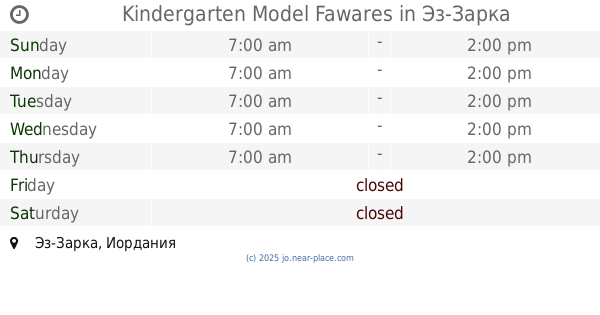
Эз-Зарка, Иордания
contacts phone
:
+962
Latitude:
32.052763
, Longitude:
36.0875475
larger map & directions
read more
nearest School
32 m
مدرسة سمية الاساسية، الزرقاء
Az-Zarqa
School
read more
444 m
Tariq bin Ziyad School
Az-Zarqa
School
read more
459 m
مدرسة معاوية بن ابي سفيان الثانوية للبنين
Az-Zarqa
School
read more
479 m
Jnaah School
Az-Zarqa
School
read more
564 m
مدرسة الزرقاء الشاملة للبنات
Az-Zarqa
School
read more
636 m
شجرة الدر
Az-Zarqa
School
read more
683 m
Kindergarten Model Fawares
Az-Zarqa
School
read more
742 m
مدرسة الاتحاد الاسلامية للبنين
Az-Zarqa
School
read more
779 m
مدارس ارض الميعاد
Az-Zarqa
School
read more
792 m
Zarqa Prep Boys School 2 - UNRWA
Az-Zarqa
School
read more
795 m
مدرسة هاني بن مسعود
Az-Zarqa
School
read more
812 m
مدرسة الزرقاء الحديثة
Az-Zarqa
School
read more
846 m
Muhammad bin Qasim Elementary Boys School
Bab Al-Wad Street, Az-Zarqa
School
read more
894 m
Zarqa Prep Girls School 1 - UNRWA
Az-Zarqa
School
read more
895 m
مدرسة الزرقاء الثانوية للبنات
Az-Zarqa
School
read more
902 m
الزرقاء الثانوية للبنات
Az-Zarqa
School
read more
951 m
مدرسة صلاح الدين الايوبي الخاصة الزرقاء وسط البلد
Az-Zarqa
School
read more
995 m
Izz el-Deen al-Qassam School
Az-Zarqa
School
read more
1.021 km
Omer bin Al Khattab Secondary School
Az-Zarqa
School
read more
1.067 km
School nobility New
Army Street, Az-Zarqa
School
read more
1.092 km
مدرسة راية بنت الحسين
Army Street, Az-Zarqa
School
read more
1.092 km
روضة الشاطئ النموذجية
16، الزرقاء الجديدة شارع، الزرقاء،
School
read more
1.097 km
مدرسة خادم الحرمين
الزرقاء الشرق شارع مدرسة، خادم الحرمين، الشريفين،
School
read more
1.157 km
مدرسة ام كلثوم الثانوية للبنات
Az-Zarqa
School
read more
1.26 km
Jabal Tareq School | مدرسة جبل طارق للذكور
Az-Zarqa
School
read more
📑
all categories
Accounting
Administrative area level 1
Administrative area level 2
Airport
Amusement park
Aquarium
Art gallery
Atm
Bakery
Bank
Bar
Beauty salon
Bicycle store
Book store
Bowling alley
Bus station
Cafe
Campground
Car dealer
Car rental
Car repair
Car wash
Cemetery
Church
City hall
Clothing store
Colloquial area
Convenience store
Country
Courthouse
Dentist
Department store
Doctor
Electrician
Electronics store
Embassy
Finance
Fire station
Florist
Food
Funeral home
Furniture store
Gas station
General contractor
Grocery or supermarket
Gym
Hair care
Hardware store
Health
Home goods store
Hospital
Insurance agency
Jewelry store
Laundry
Lawyer
Library
Liquor store
Local government office
Locality
Locksmith
Lodging
Meal delivery
Meal takeaway
Mosque
Movie rental
Movie theater
Moving company
Museum
Natural feature
Neighborhood
Night club
Painter
Park
Parking
Pet store
Pharmacy
Physiotherapist
Place of worship
Plumber
Point of interest
Police
Post office
Premise
Real estate agency
Restaurant
Route
Rv park, camping
School
Shoe store
Shopping mall
Spa
Stadium
Storage
Store
Supermarket
Taxi stand
Train station
Travel agency
University
Veterinary care
Zoo
sublocality level 1
↑