School nearby مدرسة كلية الحسين الاسياسية
Jordan
School nearby مدرسة كلية الحسين الاسياسية
مدرسة كلية الحسين الاسياسية
Khaled Ben Al-Walid Street, Amman Israel
contacts phone
:
+962
Latitude:
31.9590163
, Longitude:
35.9320593
read more
nearest School
153 m
Orosiya School
Amman
School
read more
304 m
Munther Al-Masri School
Amman
School
read more
335 m
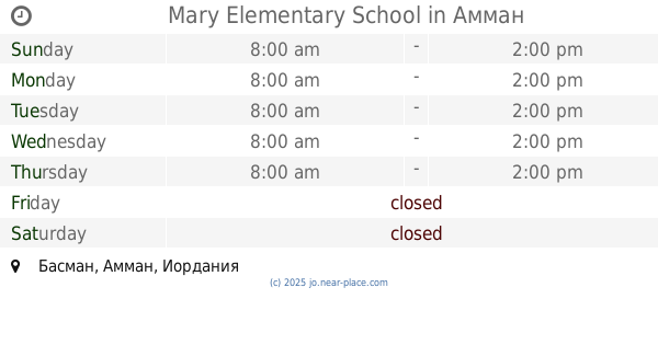
Mary Elementary School
Amman
School
read more
347 m
Ajyal Al Farooq School
Ajyal Al Farooq School, Abu Ayoub Al Ansari St 9, Amman
School
read more
436 m
عبد الحميد شرف الثانوية المهنية للبنين
Amman
School
read more
466 m
المدرسة الشريف عبد الحميد شرف
Amman
School
read more
552 m
Abd Alhamid Sharaf
ALNOMAN BIN AMR BIN RAFAA, Amman
School
read more
555 m
مدرسة الحسين الثانوية الشاملة للبنات
Amman
School
read more
602 m
مدرسة البتراء جبل الحسين
Khaled Ben Al-Walid Street, Amman
School
read more
612 m
مدرسة البتراء الأساسية المختلطة
Amman
School
read more
616 m
مدرسة الامام الشافعي الاساسية
Amman
School
read more
684 m
Al Emam Malek School
Amman
School
read more
693 m
خهوتعا
Amman
School
read more
714 m
مدرسة القصور الثانوية للبنات
Amman
School
read more
734 m
Anoud Model School Special
عمان - جبل الحسين –شارع يافا –متفرع من شارع خالد بن الوليد –ع رقم 4, Amman
School
read more
748 m
Al Anood Model Kindergarten
Al Anood Model Schools Group, Yafa St 4, Amman
School
read more
772 m
مدرسة امل اللويبدة الثانوية للصم
Al-Akhtal Street, Amman
School
read more
800 m
Al Iman Model School & Kindergarten
Al Iman Model School & Kindergarten, Mar'i Al Karmi St 23, Amman
School
read more
800 m
مركز رمضان القرآني
Amman
School
read more
858 m
Misbah Intercultural Center
Al-Shariaah College Street, Amman
School
read more
935 m
مدرسة بلاط الشهداء الأساسية المختلطة
Amman
School
read more
1.002 km
Shokri Shasha'a School
Amman
School
read more
1.003 km
المعهد العالمي للفكر الإسلامي
ش. كلية الشريعة،، عمّان
School
read more
1.115 km
Academy of the Hashemite arena for vocational training
Al-Hashemi Street, Amman
School
read more
1.15 km
سمير الرفاعي
Amman
School
read more
📑
all categories
Accounting
Administrative area level 1
Administrative area level 2
Airport
Amusement park
Aquarium
Art gallery
Atm
Bakery
Bank
Bar
Beauty salon
Bicycle store
Book store
Bowling alley
Bus station
Cafe
Campground
Car dealer
Car rental
Car repair
Car wash
Cemetery
Church
City hall
Clothing store
Colloquial area
Convenience store
Country
Courthouse
Dentist
Department store
Doctor
Electrician
Electronics store
Embassy
Finance
Fire station
Florist
Food
Funeral home
Furniture store
Gas station
General contractor
Grocery or supermarket
Gym
Hair care
Hardware store
Health
Home goods store
Hospital
Insurance agency
Jewelry store
Laundry
Lawyer
Library
Liquor store
Local government office
Locality
Locksmith
Lodging
Meal delivery
Meal takeaway
Mosque
Movie rental
Movie theater
Moving company
Museum
Natural feature
Neighborhood
Night club
Painter
Park
Parking
Pet store
Pharmacy
Physiotherapist
Place of worship
Plumber
Point of interest
Police
Post office
Premise
Real estate agency
Restaurant
Route
Rv park, camping
School
Shoe store
Shopping mall
Spa
Stadium
Storage
Store
Supermarket
Taxi stand
Train station
Travel agency
University
Veterinary care
Zoo
sublocality level 1
↑