School nearby مدرسة حوشا الثانوية للاناث
Jordan
School nearby مدرسة حوشا الثانوية للاناث
مدرسة حوشا الثانوية للاناث
Эль-Мафрак, Иордания
contacts phone
:
+962
Latitude:
32.4485575
, Longitude:
36.1014219
larger map & directions
read more
nearest School
106 m
مدرسة حوشا الثانوية للبنين
Hawshah
School
read more
225 m
مدرسة حوشا الاساسية المختلطة
School
read more
3.161 km
مدرسه فاع الثانويه للذكور
شارع مخيم غزة الرئيسي, Jerash
School
read more
3.176 km
مدرسة فاع الثانوية للبنين
School
read more
3.617 km
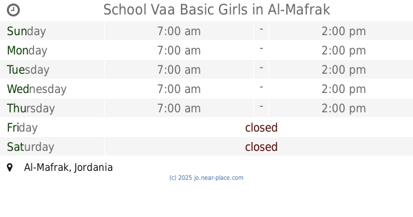
School Vaa Basic Girls
School
read more
4.411 km
مدرسة الحمراء الثانوية الشاملة للبنين
Al-Hamra
School
read more
4.584 km
مدرسة البويضه الثانوبه للبنات
School
read more
4.622 km
مدرسة الكرامة الاساسية
School
read more
4.765 km
Mushayrifah Elementary School mixed
School
read more
4.773 km
Horsh School girls dualism
الحرش مدرسه البنات الثنويه, Mafraq
School
read more
4.809 km
مدرسة البويضه الثانويه للبنين
School
read more
4.81 km
مدرسة الحرش
الحرش, Mafraq
School
read more
4.868 km
مدرسة البراءة التربوية الاساسية المختلطة
School
read more
4.959 km
مدرسة الغيث النموذية
School
read more
5.074 km
مدرسة الدندنية الاساسية للبنين
School
read more
5.632 km
مدرسة الاكيدر الثانوية للبنات
School
read more
7.829 km
Hock Elementary School
School
read more
12.11 km
اكاديمية ومدارس الثروة العلمية
Ramtha
School
read more
12.726 km
Independence School
Ramtha
School
read more
14.162 km
مدرسة عبد الله بن الزبير الاساسية للبنبن
School
read more
14.343 km
مدرسة ابو عبيدة عامر بن الجراح
Al-Mafraq
School
read more
14.614 km
حضانة تعليمية
Ramtha
School
read more
15.22 km
مدرة جمانة بنت ابي طاب
Ramtha
School
read more
15.947 km
مدرسة المفرق الاساسية الثانية
Al-Mafraq
School
read more
17.946 km
الابرار النموذجية الاساسية المختلطة
Al-Mafraq
School
read more
📑
all categories
Accounting
Administrative area level 1
Administrative area level 2
Airport
Amusement park
Aquarium
Art gallery
Atm
Bakery
Bank
Bar
Beauty salon
Bicycle store
Book store
Bowling alley
Bus station
Cafe
Campground
Car dealer
Car rental
Car repair
Car wash
Cemetery
Church
City hall
Clothing store
Colloquial area
Convenience store
Country
Courthouse
Dentist
Department store
Doctor
Electrician
Electronics store
Embassy
Finance
Fire station
Florist
Food
Funeral home
Furniture store
Gas station
General contractor
Grocery or supermarket
Gym
Hair care
Hardware store
Health
Home goods store
Hospital
Insurance agency
Jewelry store
Laundry
Lawyer
Library
Liquor store
Local government office
Locality
Locksmith
Lodging
Meal delivery
Meal takeaway
Mosque
Movie rental
Movie theater
Moving company
Museum
Natural feature
Neighborhood
Night club
Painter
Park
Parking
Pet store
Pharmacy
Physiotherapist
Place of worship
Plumber
Point of interest
Police
Post office
Premise
Real estate agency
Restaurant
Route
Rv park, camping
School
Shoe store
Shopping mall
Spa
Stadium
Storage
Store
Supermarket
Taxi stand
Train station
Travel agency
University
Veterinary care
Zoo
sublocality level 1
↑