School nearby مدرسة الشجرة الطيبة التربوية الخاصة للبنين
Coronavirus disease (COVID-19) Situation
confirmed cases
1746997
deaths
14122
Jordan
School nearby مدرسة الشجرة الطيبة التربوية الخاصة للبنين
مدرسة الشجرة الطيبة التربوية الخاصة للبنين
Эз-Зарка, Иордания
contacts phone
:
+962 7 9663 1953
Latitude:
32.091673
, Longitude:
36.0955522
larger map & directions
read more
nearest School
119 m
روضة عالم الأطفال
Az-Zarqa
School
read more
212 m
مدرسة مؤتة
Az-Zarqa
School
read more
286 m
مركز يد بيد للتربيه الخاصه
فيلا 16, الزرقاء الجديده شارع 26 بجانب مدرسه مؤته, Az-Zarqa
School
read more
413 m
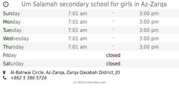
Um Salamah secondary school for girls
Al-Batrwai Circle, Az-Zarqa
School
read more
444 m
Amuriyah Schools
Az-Zarqa
School
read more
666 m
School Anwar Prophecy
Az-Zarqa
School
read more
718 m
روضة الصدارة الحديثة
الجديدة جبل المغير دوار الطوباسي
School
read more
736 m
مدارس المناهل الخاصه
Az-Zarqa
School
read more
747 m
The Gemini Training Center - مركز الجوزاء للتدريب
Az-Zarqa
School
read more
755 m
مدارس البتراوي
Az-Zarqa
School
read more
764 m
مدارس البتراوي الخاصة
Az-Zarqa
School
read more
783 m
روضة القيصر الصغير
Az-Zarqa
School
read more
817 m
مدرسة شرحبيل بن حسنة الاساسية للبنين
Az-Zarqa
School
read more
871 m
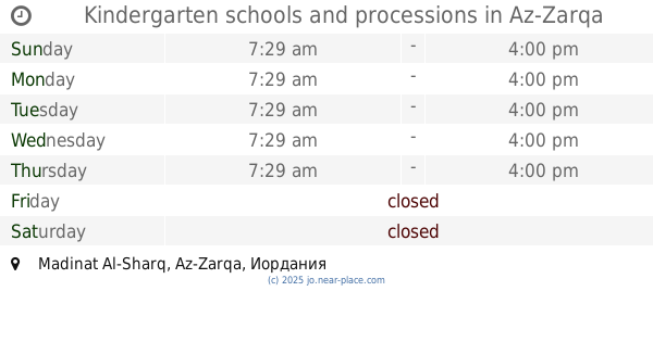
Kindergarten schools and processions
Az-Zarqa
School
read more
872 m
مدرسة ابو ذر الغفاري الاساسية للبنين
Az-Zarqa
School
read more
877 m
مدرسة نهاوند الاساسية المختلطة
Az-Zarqa
School
read more
899 m
Rabat School
Az-Zarqa
School
read more
934 m
مدارس المواكب (النبأ الحديثة )
Az-Zarqa
School
read more
943 m
Kindergarten Saad Model
Az-Zarqa
School
read more
949 m
Academy Ayham
Az-Zarqa
School
read more
951 m
مدرسة النبأ الحديثة
Az-Zarqa
School
read more
971 m
اكاديمية بلاتينيوم للتدريب
32°05'09.9"N 36°05'15., 5
School
read more
1.203 km
مدارس اكاديمية روابي الزرقاء
Az-Zarqa
School
read more
1.277 km
Kindergarten School Ibn Sirin
Az-Zarqa
School
read more
1.356 km
Hello kids Nursery
Az-Zarqa
School
read more
📑
all categories
Accounting
Administrative area level 1
Administrative area level 2
Airport
Amusement park
Aquarium
Art gallery
Atm
Bakery
Bank
Bar
Beauty salon
Bicycle store
Book store
Bowling alley
Bus station
Cafe
Campground
Car dealer
Car rental
Car repair
Car wash
Cemetery
Church
City hall
Clothing store
Colloquial area
Convenience store
Country
Courthouse
Dentist
Department store
Doctor
Electrician
Electronics store
Embassy
Finance
Fire station
Florist
Food
Funeral home
Furniture store
Gas station
General contractor
Grocery or supermarket
Gym
Hair care
Hardware store
Health
Home goods store
Hospital
Insurance agency
Jewelry store
Laundry
Lawyer
Library
Liquor store
Local government office
Locality
Locksmith
Lodging
Meal delivery
Meal takeaway
Mosque
Movie rental
Movie theater
Moving company
Museum
Natural feature
Neighborhood
Night club
Painter
Park
Parking
Pet store
Pharmacy
Physiotherapist
Place of worship
Plumber
Point of interest
Police
Post office
Premise
Real estate agency
Restaurant
Route
Rv park, camping
School
Shoe store
Shopping mall
Spa
Stadium
Storage
Store
Supermarket
Taxi stand
Train station
Travel agency
University
Veterinary care
Zoo
sublocality level 1
↑