School nearby مدرسة الراية الاردنية الخاصه
Coronavirus disease (COVID-19) Situation
confirmed cases
1746997
deaths
14122
Jordan
School nearby مدرسة الراية الاردنية الخاصه
مدرسة الراية الاردنية الخاصه
Az-Zarqa Израиль
contacts phone
:
+962
Latitude:
32.0525808
, Longitude:
36.0672475
read more
nearest School
144 m
مدرسه الامير حسن
Unnamed Road, Az-Zarqa
School
read more
186 m
مدرسه مكه الاساسيه للبنات
Az-Zarqa
School
read more
207 m
مدرسة أنور نسيبة
Az-Zarqa
School
read more
212 m
أنور نُسيبة للبنين
Az-Zarqa
School
read more
404 m
مدارس ارض الميعاد
جبل الامير حمزة
School
read more
941 m
مدرسة النهضة
Az-Zarqa
School
read more
985 m
Kindergartens and secondary schools renaissance boys
Az-Zarqa
School
read more
998 m
Princes Rahma Schools
Az-Zarqa
School
read more
1.015 km
Jabal Rahma School
Az-Zarqa
School
read more
1.028 km
School and the schools of Islamic piety
Az-Zarqa
School
read more
1.028 km
مدرسة خُطى الحبيب الاسلامية
Az-Zarqa
School
read more
1.068 km
Izz el-Deen al-Qassam School
Az-Zarqa
School
read more
1.081 km
School nobility New
Army Street, Az-Zarqa
School
read more
1.123 km
School of Omar Ibn al-Khattab Secondary
Az-Zarqa
School
read more
1.14 km
مدارس ارض الميعاد
Az-Zarqa
School
read more
1.142 km
مدرسة رابعة العدوية
Az-Zarqa
School
read more
1.529 km
Khwarizmi Basic School for Boys
ش.زهور، الزرقاء
School
read more
1.663 km
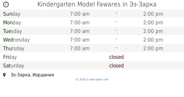
Kindergarten Model Fawares
Az-Zarqa
School
read more
1.766 km
Academy schools and kindergartens decision makers
Az-Zarqa
School
read more
1.8 km
مدرسة الزرقاء الثانوية للبنات
Az-Zarqa
School
read more
1.973 km
Al-Muhallab ibn Abi Sufra middle school
King Fisal, Az-Zarqa
School
read more
2.041 km
School Medina
Az-Zarqa
School
read more
2.044 km
مدرسة عكا الابتدائية
Az-Zarqa
School
read more
2.079 km
Muhammad bin Qasim Elementary Boys School
Bab Al-Wad Street, Az-Zarqa
School
read more
2.187 km
Islamic Union for Girls Schools
Az-Zarqa
School
read more
📑
all categories
Accounting
Administrative area level 1
Administrative area level 2
Airport
Amusement park
Aquarium
Art gallery
Atm
Bakery
Bank
Bar
Beauty salon
Bicycle store
Book store
Bowling alley
Bus station
Cafe
Campground
Car dealer
Car rental
Car repair
Car wash
Cemetery
Church
City hall
Clothing store
Colloquial area
Convenience store
Country
Courthouse
Dentist
Department store
Doctor
Electrician
Electronics store
Embassy
Finance
Fire station
Florist
Food
Funeral home
Furniture store
Gas station
General contractor
Grocery or supermarket
Gym
Hair care
Hardware store
Health
Home goods store
Hospital
Insurance agency
Jewelry store
Laundry
Lawyer
Library
Liquor store
Local government office
Locality
Locksmith
Lodging
Meal delivery
Meal takeaway
Mosque
Movie rental
Movie theater
Moving company
Museum
Natural feature
Neighborhood
Night club
Painter
Park
Parking
Pet store
Pharmacy
Physiotherapist
Place of worship
Plumber
Point of interest
Police
Post office
Premise
Real estate agency
Restaurant
Route
Rv park, camping
School
Shoe store
Shopping mall
Spa
Stadium
Storage
Store
Supermarket
Taxi stand
Train station
Travel agency
University
Veterinary care
Zoo
sublocality level 1
↑