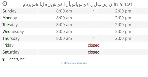
School nearby مدرسة العرامشه و الفضيين
Jordan
School nearby مدرسة العرامشه و الفضيين
مدرسة العرامشه و الفضيين
Irbid, Jordanien
contacts phone
:
+962
Latitude:
32.5631294
, Longitude:
35.6077922
larger map & directions
read more
nearest School
735 m
مدرسة العرامشة الثانوية الشاملة للبنات
School
read more
2.18 km
مدرسة وكالة غوث وقاص الإعدادية
School
read more
2.312 km
المنشيه الاغوار الشماليه
School
read more
2.372 km
مدرسة المنشية الأساسية للبنين
School
read more
2.396 km
مدرسة ذكور وإناث المنشية الإعدادية / الوكالة
School
read more
2.404 km
مدرسة المنشية الثانوية للبنات
School
read more
2.942 km
مدرسة المنشية الثانوية للبنين
School
read more
3.08 km
مدرسة الملك طلال الثانوية للبنين
School
read more
3.602 km
مدرسة قليعات الثانوية المختلطة
School
read more
3.83 km
مدرسة مخربا الثانوية الشاملة للبنين
School
read more
4.995 km
مدرسة الامير حسن / الشونه الشماليه
Hizam Ring Road, Amman
School
read more
5.231 km
مدرسة اليرموك الأساسية للبنين
North Shuna
School
read more
6.338 km
مدرسة اليرموك الاساسيه للبنين
School
read more
7.56 km
مدرسة قليعات الثانوية المختلطة
الاردن للواء
School
read more
8.453 km
صما الحي الشرقي المحجه
School
read more
9.934 km
Shehador Elementary School for Boys
Saidour
School
read more
10.145 km
صيدور الاساسيه للبنات
School
read more
10.352 km
مدرسة نسيبة المازنية - الطيبة
School
read more
12.155 km
مسجدعمر ابن الخطاب ابوالقين
School
read more
12.878 km
مدرسة مكه الثانوية للبنين
School
read more
12.937 km
Doaqra Secondary School for Boys
School
read more
13.453 km
مدرسة ديرالسعنة الثانوية للبنات
Hizam Ring Road, Amman
School
read more
13.927 km
دير السعنة الثانوية للبنين
Dayr as Si'nah
School
read more
14.691 km
روضة المسك النموذجية
Irbid
School
read more
16.64 km
مدرسة بيت ايدس الثانوية للبنات
School
read more
📑
all categories
Accounting
Administrative area level 1
Administrative area level 2
Airport
Amusement park
Aquarium
Art gallery
Atm
Bakery
Bank
Bar
Beauty salon
Bicycle store
Book store
Bowling alley
Bus station
Cafe
Campground
Car dealer
Car rental
Car repair
Car wash
Cemetery
Church
City hall
Clothing store
Colloquial area
Convenience store
Country
Courthouse
Dentist
Department store
Doctor
Electrician
Electronics store
Embassy
Finance
Fire station
Florist
Food
Funeral home
Furniture store
Gas station
General contractor
Grocery or supermarket
Gym
Hair care
Hardware store
Health
Home goods store
Hospital
Insurance agency
Jewelry store
Laundry
Lawyer
Library
Liquor store
Local government office
Locality
Locksmith
Lodging
Meal delivery
Meal takeaway
Mosque
Movie rental
Movie theater
Moving company
Museum
Natural feature
Neighborhood
Night club
Painter
Park
Parking
Pet store
Pharmacy
Physiotherapist
Place of worship
Plumber
Point of interest
Police
Post office
Premise
Real estate agency
Restaurant
Route
Rv park, camping
School
Shoe store
Shopping mall
Spa
Stadium
Storage
Store
Supermarket
Taxi stand
Train station
Travel agency
University
Veterinary care
Zoo
sublocality level 1
↑