School nearby مدرسة أديسون النموذجية
Coronavirus disease (COVID-19) Situation
confirmed cases
1746997
deaths
14122
Jordan
School nearby مدرسة أديسون النموذجية
مدرسة أديسون النموذجية
אירביד, ירדן
contacts phone
:
+962 7 9105 6464
website:
www.edisonirbid.com
Latitude:
32.4129609
, Longitude:
35.9624722
larger map & directions
read more
nearest School
2.802 km
School children Light
School
read more
3.1 km
مدارس الجامعة الامريكيه
Amman Street, Irbid
School
read more
3.11 km
AUSME
School
read more
3.355 km
مرسة عمر بن الخطاب الاساسية للبنين
School
read more
3.47 km
مدرسة عمر بن الخطاب الاساسية
School
read more
3.479 km
Balila Elementary school
School
read more
3.555 km
مدرسه بليلا الثانويه الشامله للاناث
School
read more
3.727 km
مدرسة حمد الفرحان الثانوية
School
read more
3.922 km
School Balila Secondary Boys y
Balila
School
read more
4.291 km
مدرسة ابن تيميه الاساسيه للذكور
School
read more
4.483 km
مدرسة النعيمه الاساسيه
School
read more
4.706 km
Ibn Zaidoun Elementary School for Boys
School
read more
10.517 km
مدرسة جبا الاساسية للبنات
Jerash
School
read more
11.454 km
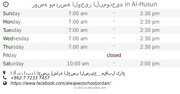
روضة ومدرسة الوجيز النموذجية
الأردن اربد الحصن, إشارة الحصن الصريح _ مقابل كراج القدس _ خلف صالون الأقصى, Al-Husun
School
read more
11.888 km
Kindergarten School Educational Mortaqa
School
read more
12.512 km
Independence School
Ramtha
School
read more
14.752 km
Aydoun High School for Girls
Aydoun
School
read more
14.857 km
مدرسة الاكيدر الثانوية للبنات
School
read more
15.702 km
مدرسة عبد الله بن الزبير الاساسية للبنبن
School
read more
16.314 km
مجموعة تقارب التعليمية
Prince Hasan Street, Irbid
School
read more
16.988 km
Online Academy
Irbid
School
read more
16.991 km
professional training Centre
Irbid
School
read more
17.125 km
مدرسة النور التربوية الاسلامية
Irbid
School
read more
17.643 km
مركز الهلال
Irbid
School
read more
17.676 km
روضة و مدرسة الإيمان التعليمية
Rateb Al-Battayenah Street, Irbid
School
read more
📑
all categories
Accounting
Administrative area level 1
Administrative area level 2
Airport
Amusement park
Aquarium
Art gallery
Atm
Bakery
Bank
Bar
Beauty salon
Bicycle store
Book store
Bowling alley
Bus station
Cafe
Campground
Car dealer
Car rental
Car repair
Car wash
Cemetery
Church
City hall
Clothing store
Colloquial area
Convenience store
Country
Courthouse
Dentist
Department store
Doctor
Electrician
Electronics store
Embassy
Finance
Fire station
Florist
Food
Funeral home
Furniture store
Gas station
General contractor
Grocery or supermarket
Gym
Hair care
Hardware store
Health
Home goods store
Hospital
Insurance agency
Jewelry store
Laundry
Lawyer
Library
Liquor store
Local government office
Locality
Locksmith
Lodging
Meal delivery
Meal takeaway
Mosque
Movie rental
Movie theater
Moving company
Museum
Natural feature
Neighborhood
Night club
Painter
Park
Parking
Pet store
Pharmacy
Physiotherapist
Place of worship
Plumber
Point of interest
Police
Post office
Premise
Real estate agency
Restaurant
Route
Rv park, camping
School
Shoe store
Shopping mall
Spa
Stadium
Storage
Store
Supermarket
Taxi stand
Train station
Travel agency
University
Veterinary care
Zoo
sublocality level 1
↑