School nearby LASIR Office
Jordan
School nearby LASIR Office
LASIR Office
Al-Injaz Street, Amman, JO Jordan
contacts phone
:
+962
Latitude:
31.9506639
, Longitude:
35.9235908
larger map & directions
read more
nearest School
216 m
Rosary Sisters School
Amro Ben Saed Street, Amman
School
read more
261 m
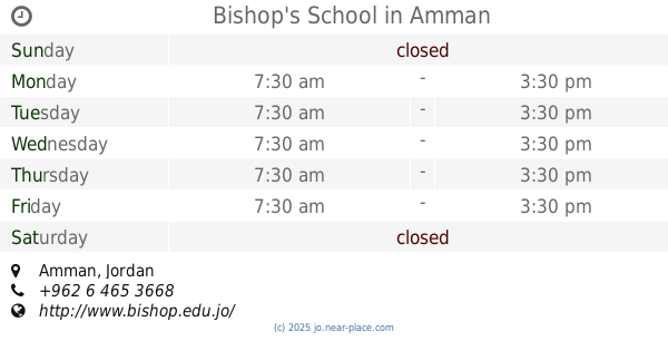
Bishop's School
Amman
School
read more
261 m
Bishop's School Amman
Amman
School
read more
261 m
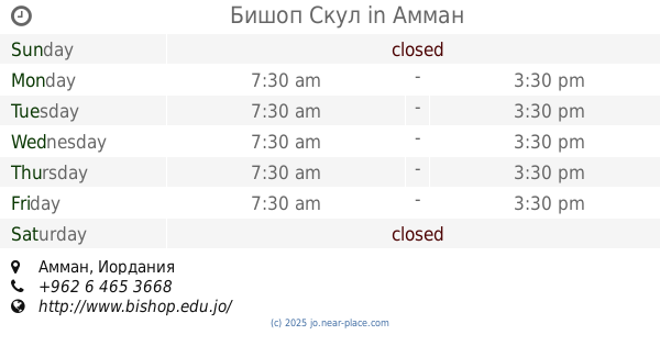
Бишоп Скул
Amman
School
read more
277 m
زين الشرف
Amman
School
read more
378 m
Колледж Айламик Эдьюкейшенал
Islamic Educational College Schools Management, Al Kulliyah Al Elmiyah Al Eslamiyah St A23, Amman
School
read more
389 m
Adventists Secondary School
Adventists Secondary School, Al Rainbow St A31, Amman
School
read more
428 m
مدرسة سمير الرفاعي اللويبدة
Arar Street, Amman
School
read more
506 m
Aisha girl Talha School
Omar Matar Street, Amman
School
read more
563 m
Hawit, Fasheh & Co
Complex No 24, Al Rainbow St 24, Amman
School
read more
630 m
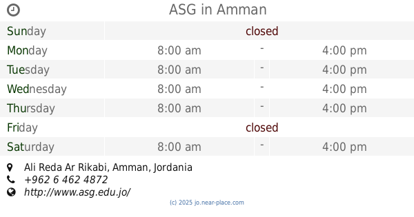
ASG
Ali Reda Ar Rikabi, Amman
School
read more
671 m
Shokri Shasha'a School
Amman
School
read more
679 m
Misbah Intercultural Center
Al-Shariaah College Street, Amman
School
read more
742 m
ciee study center
Amman
School
read more
742 m
Lubna Special Education Center
3, tabasheer, Amman
School
read more
751 m
School
Abdullah Ibn Az Zubayr, Amman
School
read more
764 m
STC School
Ahmad Shawqi Street, Amman
School
read more
792 m
Колледж Терра Санкча
Terrasanta College, Ahmad Shawqi St 26, Amman
School
read more
805 m
خهوتعا
Amman
School
read more
936 m
مدرسة راهبات الوردية - المصدار
Prince Hasan Street, Amman
School
read more
944 m
مدرسة الراهبات الوردية
Amman
School
read more
1.024 km
Ibn Abbas Holy Quran, Mount Branch Clean
Najib Al-Shuraida Street, Amman
School
read more
1.035 km
Марказ шейха Абд Аллах Аль-Мтауа
Amman
School
read more
1.07 km
Children Model Kindergarten
Children Model Kindergarten, Ahmad Shawqi St 61, Amman
School
read more
1.277 km
إدارة الامتحانات والاختبارات، وزارة التربية والتعليم
Amman
School
read more
📑
all categories
Accounting
Administrative area level 1
Administrative area level 2
Airport
Amusement park
Aquarium
Art gallery
Atm
Bakery
Bank
Bar
Beauty salon
Bicycle store
Book store
Bowling alley
Bus station
Cafe
Campground
Car dealer
Car rental
Car repair
Car wash
Cemetery
Church
City hall
Clothing store
Colloquial area
Convenience store
Country
Courthouse
Dentist
Department store
Doctor
Electrician
Electronics store
Embassy
Finance
Fire station
Florist
Food
Funeral home
Furniture store
Gas station
General contractor
Grocery or supermarket
Gym
Hair care
Hardware store
Health
Home goods store
Hospital
Insurance agency
Jewelry store
Laundry
Lawyer
Library
Liquor store
Local government office
Locality
Locksmith
Lodging
Meal delivery
Meal takeaway
Mosque
Movie rental
Movie theater
Moving company
Museum
Natural feature
Neighborhood
Night club
Painter
Park
Parking
Pet store
Pharmacy
Physiotherapist
Place of worship
Plumber
Point of interest
Police
Post office
Premise
Real estate agency
Restaurant
Route
Rv park, camping
School
Shoe store
Shopping mall
Spa
Stadium
Storage
Store
Supermarket
Taxi stand
Train station
Travel agency
University
Veterinary care
Zoo
sublocality level 1
↑