School nearby Kfaragaaz Secondary School for Girls
Jordan
School nearby Kfaragaaz Secondary School for Girls
Kfaragaaz Secondary School for Girls
Irbid, Иордания
contacts phone
:
+962
Latitude:
32.6201888
, Longitude:
35.8252596
larger map & directions
read more
nearest School
364 m
مدرسة كفرجايز الاساسية المختلطة
Irbid
School
read more
367 m
مدرسة كفرجايز للبنات
Irbid
School
read more
399 m
Kufur Jayez Secondary School
Irbid
School
read more
1.906 km
مدرسة حسين الطوالبة للبنين
School
read more
1.944 km
روضة القمة النموذجية اربد
School
read more
2.004 km
Sama Roussan Secondary School for Boys
School
read more
2.099 km
Capitolias Academy
School
read more
2.452 km
مدرسة تقبل للبنات
Ateyat Bani Hani Street, Irbid
School
read more
2.452 km
School accepts the basic Girls
مدرسة تقبل للبنات, Ateyat Bani Hani Street, Irbid
School
read more
2.627 km
مدرسة تقبل للذكور
Irbid
School
read more
2.738 km
School Ibn Rushd
School
read more
2.897 km
School accepts Elementary Boys
محافظة ام الجدايل الشمالية, Irbid
School
read more
3.183 km
مدرسة ام الجدايل المخطلطه
Irbid
School
read more
3.428 km
مدرسة بيت راس الثانوية للبنين
Irbid
School
read more
3.653 km
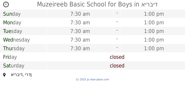
Muzeireeb Basic School for Boys
School
read more
3.946 km
Al-Hadeel Educational Institution
School
read more
4.271 km
مدرسه التطوير الحضري للبنين
Irbid
School
read more
4.567 km
مدرسة أبناء الغد التربويه
Irbid
School
read more
4.633 km
Soum Secondary School For Girls
Irbid
School
read more
4.811 km
مدرسة سوم الثانوية للبنين
Irbid
School
read more
4.852 km
Soum High School For Boys
Irbid
School
read more
4.943 km
Basic School Harima Mixed
School
read more
5.204 km
مدرسة حور الثانوية الشاملة للبنين
School
read more
5.252 km
Basic School for Boys Hatem
School
read more
5.846 km
مدرسة ابدر الثانوية للبنات
School
read more
📑
all categories
Accounting
Administrative area level 1
Administrative area level 2
Airport
Amusement park
Aquarium
Art gallery
Atm
Bakery
Bank
Bar
Beauty salon
Bicycle store
Book store
Bowling alley
Bus station
Cafe
Campground
Car dealer
Car rental
Car repair
Car wash
Cemetery
Church
City hall
Clothing store
Colloquial area
Convenience store
Country
Courthouse
Dentist
Department store
Doctor
Electrician
Electronics store
Embassy
Finance
Fire station
Florist
Food
Funeral home
Furniture store
Gas station
General contractor
Grocery or supermarket
Gym
Hair care
Hardware store
Health
Home goods store
Hospital
Insurance agency
Jewelry store
Laundry
Lawyer
Library
Liquor store
Local government office
Locality
Locksmith
Lodging
Meal delivery
Meal takeaway
Mosque
Movie rental
Movie theater
Moving company
Museum
Natural feature
Neighborhood
Night club
Painter
Park
Parking
Pet store
Pharmacy
Physiotherapist
Place of worship
Plumber
Point of interest
Police
Post office
Premise
Real estate agency
Restaurant
Route
Rv park, camping
School
Shoe store
Shopping mall
Spa
Stadium
Storage
Store
Supermarket
Taxi stand
Train station
Travel agency
University
Veterinary care
Zoo
sublocality level 1
↑