School nearby Hobrass School
Jordan
School nearby Hobrass School
Hobrass School
Irbid Governorate, Jordania
contacts phone
:
+962
Latitude:
32.6705748
, Longitude:
35.8377993
larger map & directions
read more
nearest School
391 m
Girls School
Harta
School
read more
1.264 km
Al- Hussain High-School
122, Harta
School
read more
1.362 km
مدرسة يبلا الثانوية للإناث
School
read more
1.403 km
Abla Secondary School for Boys
School
read more
1.799 km
مدرسة يبلا المختلطة
School
read more
2.253 km
Muzeireeb Basic School for Girls
School
read more
2.315 km
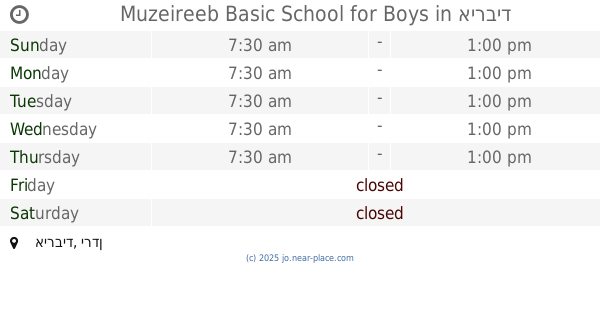
Muzeireeb Basic School for Boys
School
read more
2.411 km
مدرسة معاذ بن جبل الثانوية للبنين
School
read more
2.528 km
مدرسة حرتا الاساسية للبنين
School
read more
2.993 km
مدرسة حرثا الاساسية للبنات
School
read more
3.006 km
Kufarsum Secondary School for Girls
School
read more
3.049 km
Hartha Secondary Comprehensive School for Girls
School
read more
3.155 km
Al Khuraibah School
Irbid, Bani Kanana, Al Khuraibah
School
read more
3.28 km
Kufarsum Secondary School for Boys
School
read more
3.366 km
مدرسة كفرسوم الاساسية
School
read more
3.682 km
مدرسة زحر للبنين
شارع زحر العام
School
read more
3.792 km
Kufarsum Basic School for Girls
Kafr Sawm
School
read more
3.969 km
Sama Roussan Secondary School for Boys
School
read more
4.245 km
Rafid Secondary School for Boys
School
read more
4.257 km
Samar Secondary School for Girls
School
read more
4.333 km
Kharja school for girls
Jordan
School
read more
4.38 km
School Kharja Secondary Boys
School
read more
4.943 km
مسجد خليل الرحمن
Hizam Ring Road, Amman
School
read more
5.093 km
Kharja Elementary Boys School
School
read more
5.13 km
مدرسة ابدر الثانوية للبنات
School
read more
📑
all categories
Accounting
Administrative area level 1
Administrative area level 2
Airport
Amusement park
Aquarium
Art gallery
Atm
Bakery
Bank
Bar
Beauty salon
Bicycle store
Book store
Bowling alley
Bus station
Cafe
Campground
Car dealer
Car rental
Car repair
Car wash
Cemetery
Church
City hall
Clothing store
Colloquial area
Convenience store
Country
Courthouse
Dentist
Department store
Doctor
Electrician
Electronics store
Embassy
Finance
Fire station
Florist
Food
Funeral home
Furniture store
Gas station
General contractor
Grocery or supermarket
Gym
Hair care
Hardware store
Health
Home goods store
Hospital
Insurance agency
Jewelry store
Laundry
Lawyer
Library
Liquor store
Local government office
Locality
Locksmith
Lodging
Meal delivery
Meal takeaway
Mosque
Movie rental
Movie theater
Moving company
Museum
Natural feature
Neighborhood
Night club
Painter
Park
Parking
Pet store
Pharmacy
Physiotherapist
Place of worship
Plumber
Point of interest
Police
Post office
Premise
Real estate agency
Restaurant
Route
Rv park, camping
School
Shoe store
Shopping mall
Spa
Stadium
Storage
Store
Supermarket
Taxi stand
Train station
Travel agency
University
Veterinary care
Zoo
sublocality level 1
↑