School nearby Fidelity Kindergarten
Jordan
School nearby Fidelity Kindergarten
Fidelity Kindergarten
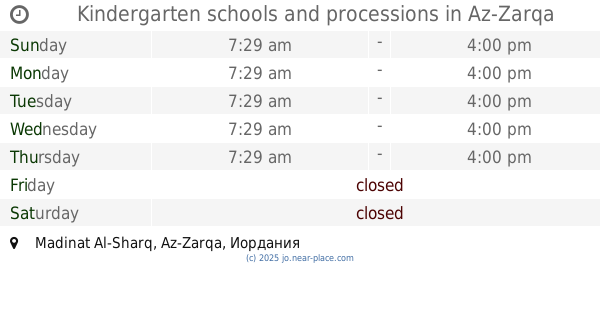
Madinat Al-Sharq, Az-Zarqa, Иордания
contacts phone
:
+962
Latitude:
32.0778511
, Longitude:
36.0962238
larger map & directions
read more
nearest School
190 m
School Khansa
Az-Zarqa
School
read more
337 m
مدرسة الامير عبدالله الاساسيه للبنين
Az-Zarqa
School
read more
407 m
مدرسة الغويرية الاساسيه
Az-Zarqa
School
read more
470 m
روضة اسرة الجندي
Az-Zarqa
School
read more
507 m
مدرسة اسماء بنت ابي بكر الاساسية للبنات
Az-Zarqa
School
read more
530 m
روضة المروج الاهليه
شارع عمر بن الخطاب،, Az-Zarqa
School
read more
577 m
Hawooz School
Az-Zarqa
School
read more
698 m
مدرسة نهاوند الاساسية المختلطة
Az-Zarqa
School
read more
778 m
مدرسة الملك غازي
Az-Zarqa
School
read more
783 m
Saeed Bin Musayyib School
مدرسه سعيد ابن المسيب
School
read more
785 m
تربية الزرقاء الثانية
Az-Zarqa
School
read more
805 m
مدرسة زبيده
Az-Zarqa
School
read more
836 m
مدرسة اجنادين الثاتوية للبنات
Az-Zarqa
School
read more
861 m
Prince Mohammed Secondary School
Az-Zarqa
School
read more
865 m
Prince Mohammed Basic School
Az-Zarqa
School
read more
902 m
Kindergarten schools and processions
Az-Zarqa
School
read more
925 m
مدرسة ابو ذر الغفاري الاساسية للبنين
Az-Zarqa
School
read more
952 m
Schools princess Rjoh
Az-Zarqa
School
read more
957 m
مركز السلام التربوي
رمزي،, Az-Zarqa
School
read more
982 m
مدرسة النبأ الحديثة
Az-Zarqa
School
read more
990 m
مدارس المواكب (النبأ الحديثة )
Az-Zarqa
School
read more
1.096 km
Greek Catholic Kindergarten North Zarqa, روضة الروم الكاثوليك الزرقاء
ش. طارق بن زياد، قرب مخابز جواد،, الشمالي, Az-Zarqa
School
read more
1.102 km
روضة الروم الكاثوليك
Az-Zarqa
School
read more
1.119 km
الكليه الفنية
Az-Zarqa
School
read more
1.221 km
اكاديمية بلاتينيوم للتدريب
32°05'09.9"N 36°05'15., 5
School
read more
📑
all categories
Accounting
Administrative area level 1
Administrative area level 2
Airport
Amusement park
Aquarium
Art gallery
Atm
Bakery
Bank
Bar
Beauty salon
Bicycle store
Book store
Bowling alley
Bus station
Cafe
Campground
Car dealer
Car rental
Car repair
Car wash
Cemetery
Church
City hall
Clothing store
Colloquial area
Convenience store
Country
Courthouse
Dentist
Department store
Doctor
Electrician
Electronics store
Embassy
Finance
Fire station
Florist
Food
Funeral home
Furniture store
Gas station
General contractor
Grocery or supermarket
Gym
Hair care
Hardware store
Health
Home goods store
Hospital
Insurance agency
Jewelry store
Laundry
Lawyer
Library
Liquor store
Local government office
Locality
Locksmith
Lodging
Meal delivery
Meal takeaway
Mosque
Movie rental
Movie theater
Moving company
Museum
Natural feature
Neighborhood
Night club
Painter
Park
Parking
Pet store
Pharmacy
Physiotherapist
Place of worship
Plumber
Point of interest
Police
Post office
Premise
Real estate agency
Restaurant
Route
Rv park, camping
School
Shoe store
Shopping mall
Spa
Stadium
Storage
Store
Supermarket
Taxi stand
Train station
Travel agency
University
Veterinary care
Zoo
sublocality level 1
↑