School nearby Ben Mekdad Black School for Boys
Jordan
School nearby Ben Mekdad Black School for Boys
Ben Mekdad Black School for Boys
Эр-Рамта, Иордания
contacts phone
:
+962 7 8688 4027
Latitude:
32.5587136
, Longitude:
36.0019753
larger map & directions
read more
nearest School
137 m
Ibn Hazm Elementary School مدرسة ابن حزم الأساسية للبنين
,الحي الغربي, Ramtha
School
read more
220 m
مدرسة مصعب بن عمير الثانوية للبنين
,الحي الغربي, Ramtha
School
read more
414 m
مركز الرمثا لقيادة السيارات والميكانيك
Ramtha
School
read more
417 m
MECI Schule Ramtha
Hamzah Ben Abdul Muttaleb Street, Ramtha
School
read more
491 m
مدرسة الزهراء الثانوية للبنات
Ramtha
School
read more
546 m
مركز ابي دجانة القرآني
Ramtha
School
read more
551 m
سكينة بنت الحسين الثانوية للبنات
Sukeinah Bent Al-Hussein Street, Ramtha
School
read more
630 m
مدرسة وأكاديمية أهل القرآن الإسلامية
Ramtha
School
read more
633 m
مسجد الشيخة صفية الكواري
Ramtha
School
read more
676 m
مدرسة النهضه
Ramtha
School
read more
676 m
مدرة جمانة بنت ابي طاب
Ramtha
School
read more
676 m
Ramtha Secondary School for Boys
Ramtha
School
read more
785 m
Arqam Elementary School
Ekremah Street, Ramtha
School
read more
924 m
Abu Dujana Center
Ramtha
School
read more
942 m
جمعية المركز الاسلامي الخيرية فرع الرمثا
Ar-Ramta
School
read more
1.093 km
مدرسة ميمونة بنت الحارث للبنات
Ramtha
School
read more
1.112 km
مدرسة الكندي الاساسية للبنين
Ramtha
School
read more
1.145 km
مدرسة جمانة بنت ابي طالب الثانوية للبنات
25, Ramtha
School
read more
1.196 km
مدرسة الفاروق الاساسية للبنين
Ramtha
School
read more
1.304 km
مدرسه ام كلثوم
Talhah Ben Ubayd Allah Street, Ramtha
School
read more
1.333 km
حضانة تعليمية
Ramtha
School
read more
1.415 km
مدرسة بلال بن رباح
Ramtha
School
read more
1.485 km
Prince Hamzah Bin Al Hussein Vocational-Secondary School for boys
Ramtha
School
read more
1.56 km
مدرسة الرمثا الثانوية للبنين AlRamtha Secondary School for Boys
Ramtha
School
read more
1.68 km
روضة تالين النموذجية
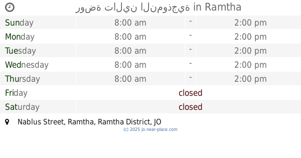
Nablus Street, Ramtha
School
read more
📑
all categories
Accounting
Administrative area level 1
Administrative area level 2
Airport
Amusement park
Aquarium
Art gallery
Atm
Bakery
Bank
Bar
Beauty salon
Bicycle store
Book store
Bowling alley
Bus station
Cafe
Campground
Car dealer
Car rental
Car repair
Car wash
Cemetery
Church
City hall
Clothing store
Colloquial area
Convenience store
Country
Courthouse
Dentist
Department store
Doctor
Electrician
Electronics store
Embassy
Finance
Fire station
Florist
Food
Funeral home
Furniture store
Gas station
General contractor
Grocery or supermarket
Gym
Hair care
Hardware store
Health
Home goods store
Hospital
Insurance agency
Jewelry store
Laundry
Lawyer
Library
Liquor store
Local government office
Locality
Locksmith
Lodging
Meal delivery
Meal takeaway
Mosque
Movie rental
Movie theater
Moving company
Museum
Natural feature
Neighborhood
Night club
Painter
Park
Parking
Pet store
Pharmacy
Physiotherapist
Place of worship
Plumber
Point of interest
Police
Post office
Premise
Real estate agency
Restaurant
Route
Rv park, camping
School
Shoe store
Shopping mall
Spa
Stadium
Storage
Store
Supermarket
Taxi stand
Train station
Travel agency
University
Veterinary care
Zoo
sublocality level 1
↑