School nearby أكاديمية ثلاثية الذكاء الدولية
Coronavirus disease (COVID-19) Situation
confirmed cases
1746997
deaths
14122
Jordan
School nearby أكاديمية ثلاثية الذكاء الدولية
أكاديمية ثلاثية الذكاء الدولية
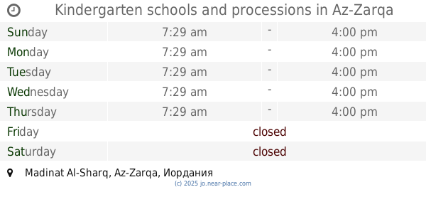
Madinat Al-Sharq, Az-Zarqa, Jordania
contacts phone
:
+962 5 386 0222
Latitude:
32.0810815
, Longitude:
36.0849417
larger map & directions
read more
nearest School
16 m
Schools and International Academy Intelligence
Az-Zarqa
School
read more
69 m
العطاء الشامل للتربية الخاصة
Az-Zarqa
School
read more
171 m
Schools princess Rjoh
Az-Zarqa
School
read more
225 m
Hello kids Nursery
Az-Zarqa
School
read more
291 m
Prince Mohammed Secondary School
Az-Zarqa
School
read more
369 m
Saeed Bin Musayyib School
مدرسه سعيد ابن المسيب
School
read more
602 m
مدرسة النبأ الحديثة
Az-Zarqa
School
read more
611 m
اكاديمية بلاتينيوم للتدريب
32°05'09.9"N 36°05'15., 5
School
read more
617 m
School Almrohlbannat
Az-Zarqa
School
read more
618 m
مدارس المواكب (النبأ الحديثة )
Az-Zarqa
School
read more
688 m
Hawooz School
Az-Zarqa
School
read more
688 m
مدرسة اسماء بنت ابي بكر الاساسية للبنات
Az-Zarqa
School
read more
710 m
مدارس طيبة الاسلامية
Az-Zarqa
School
read more
718 m
Kindergarten schools and processions
Az-Zarqa
School
read more
734 m
مدرسة زبيده
Az-Zarqa
School
read more
769 m
روضة اسرة الجندي
Az-Zarqa
School
read more
857 m
Zainab Hilal School
Army Street, Az-Zarqa
School
read more
866 m
مدرسة زينب الهلاليه الاساسية للبنات
Az-Zarqa
School
read more
873 m
تربية الزرقاء الثانية
Az-Zarqa
School
read more
944 m
مدارس المواكب الحديثة
Az-Zarqa
School
read more
954 m
مدرسه مسلمه بن عبد الملك
Az-Zarqa
School
read more
981 m
مدرسة اجنادين الثاتوية للبنات
Az-Zarqa
School
read more
1.131 km
Muslim School bin Abdul Malik
Az-Zarqa
School
read more
1.146 km
مدرسة مسلمة بن عبد الملك الأساسية للبنين
Az-Zarqa
School
read more
1.246 km
مدرسة الغويرية الاساسيه
Az-Zarqa
School
read more
📑
all categories
Accounting
Administrative area level 1
Administrative area level 2
Airport
Amusement park
Aquarium
Art gallery
Atm
Bakery
Bank
Bar
Beauty salon
Bicycle store
Book store
Bowling alley
Bus station
Cafe
Campground
Car dealer
Car rental
Car repair
Car wash
Cemetery
Church
City hall
Clothing store
Colloquial area
Convenience store
Country
Courthouse
Dentist
Department store
Doctor
Electrician
Electronics store
Embassy
Finance
Fire station
Florist
Food
Funeral home
Furniture store
Gas station
General contractor
Grocery or supermarket
Gym
Hair care
Hardware store
Health
Home goods store
Hospital
Insurance agency
Jewelry store
Laundry
Lawyer
Library
Liquor store
Local government office
Locality
Locksmith
Lodging
Meal delivery
Meal takeaway
Mosque
Movie rental
Movie theater
Moving company
Museum
Natural feature
Neighborhood
Night club
Painter
Park
Parking
Pet store
Pharmacy
Physiotherapist
Place of worship
Plumber
Point of interest
Police
Post office
Premise
Real estate agency
Restaurant
Route
Rv park, camping
School
Shoe store
Shopping mall
Spa
Stadium
Storage
Store
Supermarket
Taxi stand
Train station
Travel agency
University
Veterinary care
Zoo
sublocality level 1
↑