Restaurant nearby Pastry Spica
Coronavirus disease (COVID-19) Situation
confirmed cases
1746997
deaths
14122
Jordan
Restaurant nearby Pastry Spica
Pastry Spica
Badr, Amman, ירדן
contacts phone
:
+962
Latitude:
31.9268678
, Longitude:
35.9053678
larger map & directions
read more
nearest Restaurant
17 m
معجنات الشامي
Ad-Dustour Street, Amman
Restaurant
read more
86 m
مطعم شكري ابو جبارة
Ad-Dustour Street 213, Amman
Restaurant
read more
160 m
مطعم مستر سناك , Mr.Snack Restaurant
Amman
Restaurant
read more
162 m
Ladomena Pizza
Ad-Dustour Street 193, Amman
Restaurant
read more
250 m
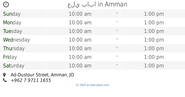
علي بابا
Ad-Dustour Street, Amman
Restaurant
read more
284 m
مطعم حماده
Amman
Restaurant
read more
301 m
Hamza Yaqoub Falafel Restaurant
Al-Khazraj Street, Amman
Restaurant
read more
323 m
Al Kaf Al Thahabi Restaurant
Complex No 22, Al Nabeghah Al Jadi St 22, Amman
Restaurant
read more
342 m
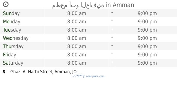
مطعم أبو العافية
Ghazi Al-Harbi Street, Amman
Restaurant
read more
407 m
Ghazal Restaurants
Amman
Restaurant
read more
453 m
معجنات مسدي
Amman
Restaurant
read more
567 m
مطعم الخالد
Ad-Dustour Street, Amman
Restaurant
read more
567 m
Magic Land Pizza
Ad-Dustour Street, Amman
Restaurant
read more
593 m
مطعم عالية المركزي
Amman
Restaurant
read more
638 m
شاورما عبق الياسمين
Al-Shura Street, Amman
Restaurant
read more
727 m
مطعم الزين
Ad-Dustour Street, Amman
Restaurant
read more
802 m
مطبخ النرجس للتواصي
Alyasmeen, Shura St., Amman
Restaurant
read more
879 m
Magic Pizza مجك بيتزا
Ad-Dustour Street, Amman
Restaurant
read more
932 m
بيتزا فاكتوري
Amman
Restaurant
read more
969 m
Jewel Restaurant Shamia
Al-Haram Street, Amman
Restaurant
read more
1.095 km
مطعم رائحة الياسمين
الحمرانية،, Amman
Restaurant
read more
1.133 km
مطعم نادر الشوعاني
Amman
Restaurant
read more
1.308 km
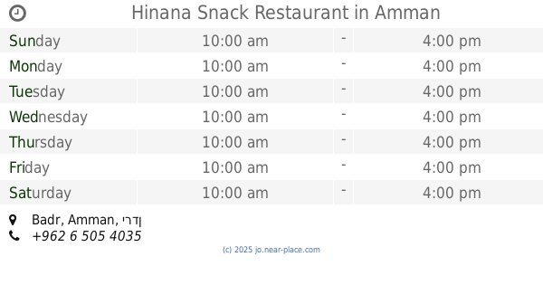
Hinana Snack Restaurant
Amman
Restaurant
read more
1.336 km
Jerusalem Markets Butchery & Grills
Complex No 101, Al Dustour St 101, Amman
Restaurant
read more
1.363 km
Bakeries Hamza Alaorani
Amman
Restaurant
read more
📑
all categories
Accounting
Administrative area level 1
Administrative area level 2
Airport
Amusement park
Aquarium
Art gallery
Atm
Bakery
Bank
Bar
Beauty salon
Bicycle store
Book store
Bowling alley
Bus station
Cafe
Campground
Car dealer
Car rental
Car repair
Car wash
Cemetery
Church
City hall
Clothing store
Colloquial area
Convenience store
Country
Courthouse
Dentist
Department store
Doctor
Electrician
Electronics store
Embassy
Finance
Fire station
Florist
Food
Funeral home
Furniture store
Gas station
General contractor
Grocery or supermarket
Gym
Hair care
Hardware store
Health
Home goods store
Hospital
Insurance agency
Jewelry store
Laundry
Lawyer
Library
Liquor store
Local government office
Locality
Locksmith
Lodging
Meal delivery
Meal takeaway
Mosque
Movie rental
Movie theater
Moving company
Museum
Natural feature
Neighborhood
Night club
Painter
Park
Parking
Pet store
Pharmacy
Physiotherapist
Place of worship
Plumber
Point of interest
Police
Post office
Premise
Real estate agency
Restaurant
Route
Rv park, camping
School
Shoe store
Shopping mall
Spa
Stadium
Storage
Store
Supermarket
Taxi stand
Train station
Travel agency
University
Veterinary care
Zoo
sublocality level 1
↑