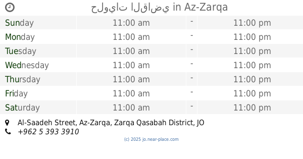
Restaurant nearby مطعم تنور الضيعة
Jordan
Restaurant nearby مطعم تنور الضيعة
مطعم تنور الضيعة
מחוז זרקא, ירדן
contacts phone
:
+962 7 9509 9989
Latitude:
32.1332966
, Longitude:
36.0446724
larger map & directions
read more
nearest Restaurant
2.176 km
مطعم ابو الكرم
Hizam Ring Road, Amman
Restaurant
read more
2.396 km
Special meal Y..j Restaurant
As-Sukhnah
Restaurant
read more
5.568 km
مطاعم شرف
Az-Zarqa
Restaurant
read more
5.574 km
ملحمة ومشاوي السيران
Az-Zarqa
Restaurant
read more
5.578 km
FORON Pizza
Az-Zarqa
Restaurant
read more
5.596 km
الفرن ...بيتزا واكثر
شارع الكرامة, Amman
Restaurant
read more
5.598 km
Pineberry Cafe'
Az-Zarqa
Restaurant
read more
5.629 km
مقهى جوري
Unnamed Road, Az-Zarqa
Restaurant
read more
5.692 km
Raba Shawarma and Restaurant
Az-Zarqa
Restaurant
read more
6.023 km
Restaurant Ayam Zaman
Az-Zarqa
Restaurant
read more
6.359 km
مطعم زنجر سناك ZENGER SNACK
New 26 street, Az-Zarqa
Restaurant
read more
6.369 km
Zinger Snack
Az-Zarqa
Restaurant
read more
6.388 km
Teto Snack
Az-Zarqa
Restaurant
read more
6.408 km
دواجن الظليل
Az-Zarqa
Restaurant
read more
6.426 km
مطعم classic burgers
Az-Zarqa
Restaurant
read more
6.529 km
مطعم الحواري
Restaurant
read more
6.755 km
مطعم نار شيكن
Az-Zarqa
Restaurant
read more
6.848 km
مطعم سوراي
Az-Zarqa
Restaurant
read more
6.968 km
Hottydogs
Az-Zarqa
Restaurant
read more
7.009 km
شاورما الوجبة الشهية
16, Army Street
Restaurant
read more
7.019 km
مطعم المرجان سناك
Az-Zarqa
Restaurant
read more
8.817 km
حلويات القاضي
Al-Saadeh Street, Az-Zarqa
Restaurant
read more
11.596 km
مطعم صاجيه ومنسف حبوب
الزرقاء،
Restaurant
read more
12.821 km
شاورما أوراق الخريف
King Hussein Street, Russayfah
Restaurant
read more
17.327 km
Al Jezawi Restaurant & Grill
Abu Alia, Amman
Restaurant
read more
📑
all categories
Accounting
Administrative area level 1
Administrative area level 2
Airport
Amusement park
Aquarium
Art gallery
Atm
Bakery
Bank
Bar
Beauty salon
Bicycle store
Book store
Bowling alley
Bus station
Cafe
Campground
Car dealer
Car rental
Car repair
Car wash
Cemetery
Church
City hall
Clothing store
Colloquial area
Convenience store
Country
Courthouse
Dentist
Department store
Doctor
Electrician
Electronics store
Embassy
Finance
Fire station
Florist
Food
Funeral home
Furniture store
Gas station
General contractor
Grocery or supermarket
Gym
Hair care
Hardware store
Health
Home goods store
Hospital
Insurance agency
Jewelry store
Laundry
Lawyer
Library
Liquor store
Local government office
Locality
Locksmith
Lodging
Meal delivery
Meal takeaway
Mosque
Movie rental
Movie theater
Moving company
Museum
Natural feature
Neighborhood
Night club
Painter
Park
Parking
Pet store
Pharmacy
Physiotherapist
Place of worship
Plumber
Point of interest
Police
Post office
Premise
Real estate agency
Restaurant
Route
Rv park, camping
School
Shoe store
Shopping mall
Spa
Stadium
Storage
Store
Supermarket
Taxi stand
Train station
Travel agency
University
Veterinary care
Zoo
sublocality level 1
↑