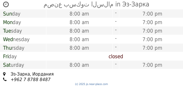
Restaurant nearby مطعم الصباريني
Jordan
Restaurant nearby مطعم الصباريني
مطعم الصباريني
شارع، Az-Zarqa, Иордания
contacts phone
:
+962
Latitude:
32.07504
, Longitude:
36.0821697
larger map & directions
read more
nearest Restaurant
366 m
ملحمة ومشاوي الخضراوي
رمزي، الزرقاء،
Restaurant
read more
447 m
parrilla restaurant
Az-Zarqa
Restaurant
read more
658 m
Valley Olive Restaurant
Az-Zarqa
Restaurant
read more
664 m
مطعم باب الحارة
Az-Zarqa
Restaurant
read more
673 m
Restaurant a neighbor's son
Az-Zarqa
Restaurant
read more
755 m
ملحمه ومشاوي ام القرى
Az-Zarqa
Restaurant
read more
763 m
Brown's Restaurant Chicken Tikka
Az-Zarqa
Restaurant
read more
771 m
Twines Restaurant
حي معصوم شارع المفروشات
Restaurant
read more
771 m
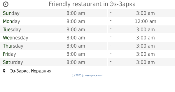
Friendly restaurant
Az-Zarqa
Restaurant
read more
795 m
مطعم عال العال
البساتين،, Az-Zarqa
Restaurant
read more
798 m
حلويات القاضي
Az-Zarqa
Restaurant
read more
811 m
First Good Restaurant
Az-Zarqa
Restaurant
read more
852 m
معجنات عامر
Ma'soum Circle, Az-Zarqa
Restaurant
read more
873 m
مطاعم عبود
Az-Zarqa
Restaurant
read more
875 m
Al-Hussein neighborhood restaurant
Az-Zarqa
Restaurant
read more
885 m
Abu Khaled Restaurant
Az-Zarqa
Restaurant
read more
888 m
Abboud Cafe and Restaurant
Unnamed Road, حي شارع عماد الدين زنكي, Az-Zarqa
Restaurant
read more
891 m
مطعم الطيب
Az-Zarqa
Restaurant
read more
899 m
مطعم ابو طه
Az-Zarqa
Restaurant
read more
918 m
مطعم ابراهيم
Al Hussein
Restaurant
read more
1.044 km
مصنع بسكوت السلام
الوسط التجاري،، الزرقاء
Restaurant
read more
1.044 km
مصنع بسكوت السلام
Az-Zarqa
Restaurant
read more
1.128 km
مطعم الزهراء
Bab Al-Wad Street, Az-Zarqa
Restaurant
read more
1.196 km
حلويات ابو قاسم
تقاطع شارع الامير هاشم مع شارع الامير حسن
Restaurant
read more
1.265 km
abu Nafe
Az-Zarqa
Restaurant
read more
📑
all categories
Accounting
Administrative area level 1
Administrative area level 2
Airport
Amusement park
Aquarium
Art gallery
Atm
Bakery
Bank
Bar
Beauty salon
Bicycle store
Book store
Bowling alley
Bus station
Cafe
Campground
Car dealer
Car rental
Car repair
Car wash
Cemetery
Church
City hall
Clothing store
Colloquial area
Convenience store
Country
Courthouse
Dentist
Department store
Doctor
Electrician
Electronics store
Embassy
Finance
Fire station
Florist
Food
Funeral home
Furniture store
Gas station
General contractor
Grocery or supermarket
Gym
Hair care
Hardware store
Health
Home goods store
Hospital
Insurance agency
Jewelry store
Laundry
Lawyer
Library
Liquor store
Local government office
Locality
Locksmith
Lodging
Meal delivery
Meal takeaway
Mosque
Movie rental
Movie theater
Moving company
Museum
Natural feature
Neighborhood
Night club
Painter
Park
Parking
Pet store
Pharmacy
Physiotherapist
Place of worship
Plumber
Point of interest
Police
Post office
Premise
Real estate agency
Restaurant
Route
Rv park, camping
School
Shoe store
Shopping mall
Spa
Stadium
Storage
Store
Supermarket
Taxi stand
Train station
Travel agency
University
Veterinary care
Zoo
sublocality level 1
↑