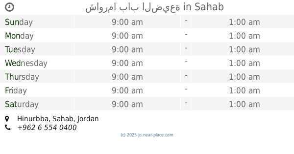
Restaurant nearby مطبخ الطيبات
Coronavirus disease (COVID-19) Situation
confirmed cases
1746997
deaths
14122
Jordan
Restaurant nearby مطبخ الطيبات
مطبخ الطيبات
Sahab, Ammán, Jordania
contacts phone
:
+962 7 9969 8401
website:
plus.google.com
Latitude:
31.8661768
, Longitude:
36.0016193
larger map & directions
read more
nearest Restaurant
406 m
مطعم الماضي
Amman
Restaurant
read more
482 m
Yemeni Table Restaurant
Amman
Restaurant
read more
485 m
مطعم الديوان
Amman
Restaurant
read more
517 m
Hamada
Industrial City Road 41, Sahab
Restaurant
read more
521 m
Bawadi Sahab
Sahab
Restaurant
read more
525 m
Abuzaghleh
Al-Shuhada Circle, Amman
Restaurant
read more
562 m
مطعم دوار الشهيد
Sahab Street, Amman
Restaurant
read more
570 m
مطعم الناصر مندي
Complex No A289, Sahab St A289, Amman
Restaurant
read more
583 m
Restaurants and Sweets Abolph
Sahab Street, Amman
Restaurant
read more
588 m
مطعم ربوع عدن 2
سحاب،, Amman
Restaurant
read more
591 m
Shawerma AnNaser
Amman
Restaurant
read more
593 m
مطعم عدن للمندى
ش. سحاب،, Amman
Restaurant
read more
607 m
Sixty Street Restaurant
سحاب، عمّان
Restaurant
read more
610 m
Baraka Broasted
Amman
Restaurant
read more
614 m
شاورما باب الضيعة
Sahab
Restaurant
read more
689 m
avocado Time افوكادو
Unnamed Road, Amman
Restaurant
read more
703 m
مطبخ ابو موسى للتواصي 0797460016
Unnamed Road, Amman
Restaurant
read more
703 m
مطعم ابو دية
Amman
Restaurant
read more
743 m
Samaya
Taha Khalid Aqil, Sahab
Restaurant
read more
800 m
شاورما عربي غربي
Sahab Street, Amman
Restaurant
read more
804 m
مطعم ومشاوي الحسام
Amman
Restaurant
read more
819 m
مطعم ماجد للفلافل
Sahab Street, Amman
Restaurant
read more
834 m
Abu Al Noor Restaurant
Bashir Al Deraidi Complex, Unnamed 3, Amman
Restaurant
read more
893 m
Flower Slboud Restaurant
Hizam Ring Road, Amman
Restaurant
read more
919 m
Sama Butchery & Restaurant
Complex No 268, Sahab St 268, Amman
Restaurant
read more
📑
all categories
Accounting
Administrative area level 1
Administrative area level 2
Airport
Amusement park
Aquarium
Art gallery
Atm
Bakery
Bank
Bar
Beauty salon
Bicycle store
Book store
Bowling alley
Bus station
Cafe
Campground
Car dealer
Car rental
Car repair
Car wash
Cemetery
Church
City hall
Clothing store
Colloquial area
Convenience store
Country
Courthouse
Dentist
Department store
Doctor
Electrician
Electronics store
Embassy
Finance
Fire station
Florist
Food
Funeral home
Furniture store
Gas station
General contractor
Grocery or supermarket
Gym
Hair care
Hardware store
Health
Home goods store
Hospital
Insurance agency
Jewelry store
Laundry
Lawyer
Library
Liquor store
Local government office
Locality
Locksmith
Lodging
Meal delivery
Meal takeaway
Mosque
Movie rental
Movie theater
Moving company
Museum
Natural feature
Neighborhood
Night club
Painter
Park
Parking
Pet store
Pharmacy
Physiotherapist
Place of worship
Plumber
Point of interest
Police
Post office
Premise
Real estate agency
Restaurant
Route
Rv park, camping
School
Shoe store
Shopping mall
Spa
Stadium
Storage
Store
Supermarket
Taxi stand
Train station
Travel agency
University
Veterinary care
Zoo
sublocality level 1
↑