Restaurant nearby ملحمة ومشاوي ابو الامير
Coronavirus disease (COVID-19) Situation
confirmed cases
1746997
deaths
14122
Jordan
Restaurant nearby ملحمة ومشاوي ابو الامير
ملحمة ومشاوي ابو الامير
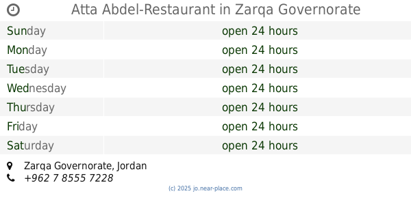
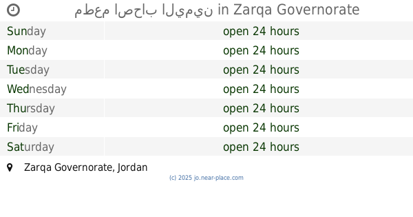
Zarqa Governorate, Jordan
contacts phone
:
+962 7 7590 9006
Latitude:
32.1266153
, Longitude:
36.1183262
larger map & directions
read more
nearest Restaurant
72 m
مطعم سندكم
Restaurant
read more
677 m
Abu Ahmed Restaurant
Restaurant
read more
868 m
مطعم الحواري
Restaurant
read more
872 m
مطعم الحرم
Restaurant
read more
1.044 km
Atta Abdel-Restaurant
Restaurant
read more
1.178 km
مطعم الريان
Hizam Ring Road, Amman
Restaurant
read more
1.187 km
مطعم اربيكانا سناك
Restaurant
read more
1.244 km
مطعم اصحاب اليمين
Restaurant
read more
1.338 km
Hachtaj Snack
Al Hashemiya
Restaurant
read more
1.353 km
Zia Homosany Restaurant
Restaurant
read more
1.396 km
The epic and the farmer grills
25
Restaurant
read more
1.667 km
مطعم الجوريشي
Restaurant
read more
1.736 km
مطعم أبو صالح
لواء, الهاشمية
Restaurant
read more
1.815 km
مطعم شراك سناك
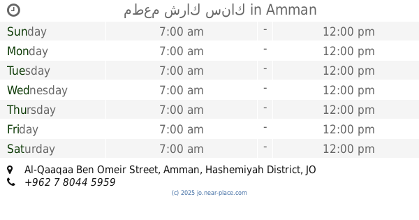
Al-Qaaqaa Ben Omeir Street, Amman
Restaurant
read more
1.937 km
مطعم خيوط الشمس (جلسات عائلية وصالة العاب للاطفال) الزرقاء الجديدة
Al Hashimeiyah Al Janobiyah, Az-Zarqa
Restaurant
read more
1.937 km
مطعم خيوط الشمس (جلسات عائلية وصالة العاب للاطفال) الزرقاء الجديدة
Az-Zarqa
Restaurant
read more
1.94 km
مطعم خيوط الشمس
Az-Zarqa
Restaurant
read more
1.94 km
مطعم خيوط الشمس
Al Hashimeiyah Al Janobiyah, Az-Zarqa
Restaurant
read more
2.691 km
Atta Abdul Restaurant _ Section II
طريق الهاشميه بجانب مدينه داخل كازيه جوبترول, Az-Zarqa
Restaurant
read more
3.475 km
Mella Café And Restaurants
Al-Batrwai Circle, Az-Zarqa
Restaurant
read more
3.478 km
relax-resturant&caffe
البتراوي،, Az-Zarqa
Restaurant
read more
3.531 km
مطعم سوراي
Az-Zarqa
Restaurant
read more
4.033 km
Pineberry Cafe'
Az-Zarqa
Restaurant
read more
4.039 km
الفرن ...بيتزا واكثر
شارع الكرامة, Amman
Restaurant
read more
4.057 km
FORON Pizza
Az-Zarqa
Restaurant
read more
📑
all categories
Accounting
Administrative area level 1
Administrative area level 2
Airport
Amusement park
Aquarium
Art gallery
Atm
Bakery
Bank
Bar
Beauty salon
Bicycle store
Book store
Bowling alley
Bus station
Cafe
Campground
Car dealer
Car rental
Car repair
Car wash
Cemetery
Church
City hall
Clothing store
Colloquial area
Convenience store
Country
Courthouse
Dentist
Department store
Doctor
Electrician
Electronics store
Embassy
Finance
Fire station
Florist
Food
Funeral home
Furniture store
Gas station
General contractor
Grocery or supermarket
Gym
Hair care
Hardware store
Health
Home goods store
Hospital
Insurance agency
Jewelry store
Laundry
Lawyer
Library
Liquor store
Local government office
Locality
Locksmith
Lodging
Meal delivery
Meal takeaway
Mosque
Movie rental
Movie theater
Moving company
Museum
Natural feature
Neighborhood
Night club
Painter
Park
Parking
Pet store
Pharmacy
Physiotherapist
Place of worship
Plumber
Point of interest
Police
Post office
Premise
Real estate agency
Restaurant
Route
Rv park, camping
School
Shoe store
Shopping mall
Spa
Stadium
Storage
Store
Supermarket
Taxi stand
Train station
Travel agency
University
Veterinary care
Zoo
sublocality level 1
↑