Restaurant nearby هريشة عيسى درويش
Jordan
Restaurant nearby هريشة عيسى درويش
هريشة عيسى درويش
King Husayn, Ma'an, Ma'an Qasabah District, JO Иордания
contacts phone
:
+962
Latitude:
30.1935919
, Longitude:
35.7357198
larger map & directions
read more
nearest Restaurant
156 m
محمص البتراء
King Hussein Street, Ma'an
Restaurant
read more
187 m
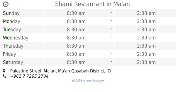
Shami Restaurant
Palestine Street, Ma'an
Restaurant
read more
194 m
مطعم السلطان
شارع فلسطين, مقابل حلويات العفوري, Ma'an
Restaurant
read more
204 m
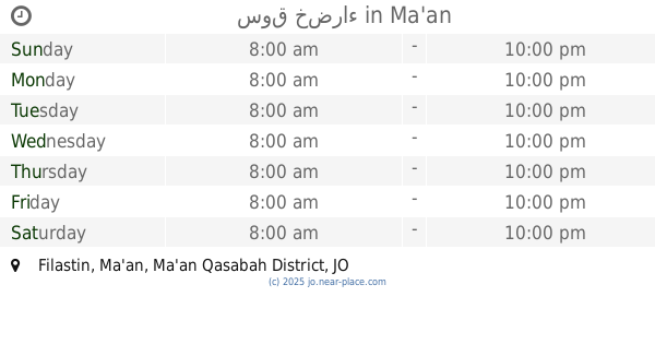
سوق خضراء
Filastin, Ma'an
Restaurant
read more
218 m
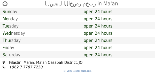
السهل الاخضر مخبز
Filastin, Ma'an
Restaurant
read more
226 m
Aquarium restaurant Bear for Fresh Fish
King Hussein Street, Ma'an
Restaurant
read more
232 m
Abu Stayf Restaurant
Al-Bayarah Street, Ma'an
Restaurant
read more
296 m
صالة ومطعم حمودة
Filastin, Ma'an
Restaurant
read more
303 m
Turkish Restaurant
King Husayn, Ma'an
Restaurant
read more
324 m
البخاري
King Husayn, Ma'an
Restaurant
read more
326 m
مطعم العنود
Palestine Street, Ma'an
Restaurant
read more
330 m
مطعم جرة الخير
Palestine Street, Ma'an
Restaurant
read more
409 m
محلات البركة للخضار والفواكة
Ma'an
Restaurant
read more
422 m
مطعم يا كريم
King Husayn, Ma'an
Restaurant
read more
526 m
صالة الرحمة
Abu Hanifa, Ma'an
Restaurant
read more
559 m
مطعم المملكة
Unnamed Road, Ma'an
Restaurant
read more
649 m
مطعم الروضة
Filastin, Ma'an
Restaurant
read more
962 m
مطعم جمره
شارع الاشغال العامه
Restaurant
read more
993 m
مطعم ومسمكة الدب
Ma'an
Restaurant
read more
1.008 km
فندق تبوك
Maan Al-Jadid, Ma'an
Restaurant
read more
1.081 km
زيد للافراح والمناسبات
Qasr Al-Adl, Ma'an
Restaurant
read more
1.09 km
Haormera Restaurant
Muaweyah Ben Abi Sufyan Street, Ma'an
Restaurant
read more
1.09 km
حميمة للخضار والفاكة
Maan Al-Jadid, Ma'an
Restaurant
read more
1.102 km
كفتيرياء السرايا
Maan Al-Jadid, Ma'an
Restaurant
read more
1.385 km
امبراطوريه محمد كريشان
Ma'an
Restaurant
read more
📑
all categories
Accounting
Administrative area level 1
Administrative area level 2
Airport
Amusement park
Aquarium
Art gallery
Atm
Bakery
Bank
Bar
Beauty salon
Bicycle store
Book store
Bowling alley
Bus station
Cafe
Campground
Car dealer
Car rental
Car repair
Car wash
Cemetery
Church
City hall
Clothing store
Colloquial area
Convenience store
Country
Courthouse
Dentist
Department store
Doctor
Electrician
Electronics store
Embassy
Finance
Fire station
Florist
Food
Funeral home
Furniture store
Gas station
General contractor
Grocery or supermarket
Gym
Hair care
Hardware store
Health
Home goods store
Hospital
Insurance agency
Jewelry store
Laundry
Lawyer
Library
Liquor store
Local government office
Locality
Locksmith
Lodging
Meal delivery
Meal takeaway
Mosque
Movie rental
Movie theater
Moving company
Museum
Natural feature
Neighborhood
Night club
Painter
Park
Parking
Pet store
Pharmacy
Physiotherapist
Place of worship
Plumber
Point of interest
Police
Post office
Premise
Real estate agency
Restaurant
Route
Rv park, camping
School
Shoe store
Shopping mall
Spa
Stadium
Storage
Store
Supermarket
Taxi stand
Train station
Travel agency
University
Veterinary care
Zoo
sublocality level 1
↑