Restaurant nearby Al Mankal
Coronavirus disease (COVID-19) Situation
confirmed cases
1746997
deaths
14122
Jordan
Restaurant nearby Al Mankal
Al Mankal
Амман, Иордания
contacts phone
:
+962 6 533 8399
Latitude:
32.0250545
, Longitude:
35.8562157
larger map & directions
read more
nearest Restaurant
26 m
مطعم العنيف الجبيهة
Ar-Rawaah Street, Amman
Restaurant
read more
421 m
Cherry Tut Restaurant Sweileh
Queen Rania Street, Amman
Restaurant
read more
453 m
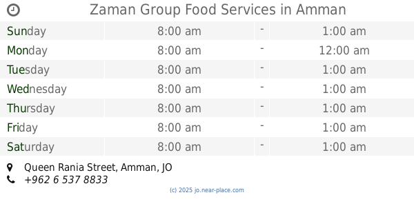
Zaman Group Food Services
Queen Rania Street, Amman
Restaurant
read more
472 m
مطعم عامر
Abdul Hamid Nuaimi Street, Amman
Restaurant
read more
524 m
الشراع الذهبي
JO, 11910 Queen Rania Street صويلح, Amman
Restaurant
read more
574 m
Mukalla Restaurant Food Yemen
Amman
Restaurant
read more
599 m
خآن زيد
Amman
Restaurant
read more
820 m
ertt
Ibrhim Abu Rumman, Amman
Restaurant
read more
829 m
Al Demashkia Resturant مطعم الدمشقية
الجبيهة شارع ياجوز اشارات الجبيهة مقابل البنك العربي, Amman
Restaurant
read more
869 m
مطعم الفوال صويلح
Amman
Restaurant
read more
883 m
مطعم نضال الكلحه
Amman
Restaurant
read more
893 m
Islamic Chinese Restaurant
of, Al-Urdon Street, Amman
Restaurant
read more
914 m
Countryside grills
Amman
Restaurant
read more
927 m
Brothers
Yajouz Road, Amman
Restaurant
read more
931 m
Al Hommosani Restaurant مطعم الحمصاني
Rifaa Al-Ansari Street, Amman
Restaurant
read more
931 m
مطعم الساخن
Queen Rania Street, Amman
Restaurant
read more
951 m
Firefly Burger
منطقة الجبيهة, Amman
Restaurant
read more
989 m
Annadina Restaurant
Amman
Restaurant
read more
989 m
Al Amin Restaurant
Al Baddad Commercial Complex, Queen Rania Al Abdullah St 434
Restaurant
read more
991 m
Alsdeeq Resturant
Amman
Restaurant
read more
1.001 km
Yazan abo leel
Rifaa Al-Ansari Street, Amman
Restaurant
read more
1.004 km
icafe
Queen Rania Street 309, Amman
Restaurant
read more
1.055 km
Kumpir
Amman
Restaurant
read more
1.072 km
مطعم ٱزال للمأكولات اليمنية والخليجية
Amman
Restaurant
read more
1.196 km
Al-Ashqar Restaurant
Rifaa Al-Ansari Street, Amman
Restaurant
read more
📑
all categories
Accounting
Administrative area level 1
Administrative area level 2
Airport
Amusement park
Aquarium
Art gallery
Atm
Bakery
Bank
Bar
Beauty salon
Bicycle store
Book store
Bowling alley
Bus station
Cafe
Campground
Car dealer
Car rental
Car repair
Car wash
Cemetery
Church
City hall
Clothing store
Colloquial area
Convenience store
Country
Courthouse
Dentist
Department store
Doctor
Electrician
Electronics store
Embassy
Finance
Fire station
Florist
Food
Funeral home
Furniture store
Gas station
General contractor
Grocery or supermarket
Gym
Hair care
Hardware store
Health
Home goods store
Hospital
Insurance agency
Jewelry store
Laundry
Lawyer
Library
Liquor store
Local government office
Locality
Locksmith
Lodging
Meal delivery
Meal takeaway
Mosque
Movie rental
Movie theater
Moving company
Museum
Natural feature
Neighborhood
Night club
Painter
Park
Parking
Pet store
Pharmacy
Physiotherapist
Place of worship
Plumber
Point of interest
Police
Post office
Premise
Real estate agency
Restaurant
Route
Rv park, camping
School
Shoe store
Shopping mall
Spa
Stadium
Storage
Store
Supermarket
Taxi stand
Train station
Travel agency
University
Veterinary care
Zoo
sublocality level 1
↑