Restaurant nearby ادم للتواصي
Jordan
Restaurant nearby ادم للتواصي
ادم للتواصي
Wadi As-Seir, Amman, Jordan
contacts phone
:
+962
Latitude:
31.964219
, Longitude:
35.863959
larger map & directions
read more
nearest Restaurant
123 m
KBOB (한국식당)
Ismail Yaamouri Street, Amman
Restaurant
read more
605 m
الراية الشامية مطعم اول شمال المطعم عاليمين
At-Tabashir Street, Amman
Restaurant
read more
630 m
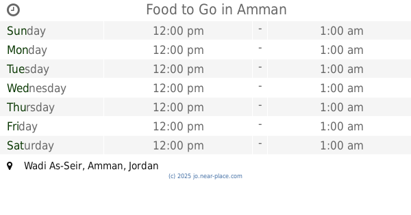
Food to Go
Amman
Restaurant
read more
690 m
מקדונלד'ס
Complex No 15, Abd Al Rahim Al Hajj Mohammad St 15, Amman
Restaurant
read more
739 m
Papa John's
6th Circle, Amman
Restaurant
read more
748 m
Mousa Al Tayeb Restaurant
Madi Commercial Complex, Hussein Al Thoum St 3, Amman
Restaurant
read more
769 m
Popeyes® Louisana Kitchen
6th Circle, Amman
Restaurant
read more
772 m
Kalha Restaurant
Amman
Restaurant
read more
786 m
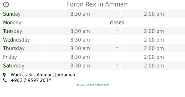
Foron Rex
Amman
Restaurant
read more
789 m
شاورما ع صاج - Shawerma 3a Saj
Amman
Restaurant
read more
797 m
شاورما ريم
Amman
Restaurant
read more
797 m
Go Crepe And Waffle
Amman
Restaurant
read more
812 m
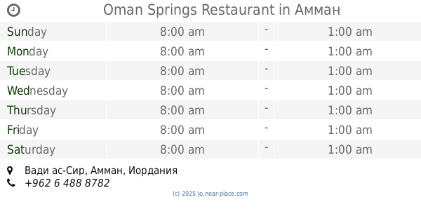
Oman Springs Restaurant
Amman
Restaurant
read more
818 m
Kholnjan Arabic Food Restaurant
Complex No B9, Subhi Al Omari St B9, Amman
Restaurant
read more
823 m
Drift Resturant
7, Jameel Center Al Fadel Bin, Al Amir Hasan, Amman
Restaurant
read more
823 m
Salwa & Fayrouz Pastries
Complex No 3, Mohammad Al Shararqah St 3, Amman
Restaurant
read more
845 m
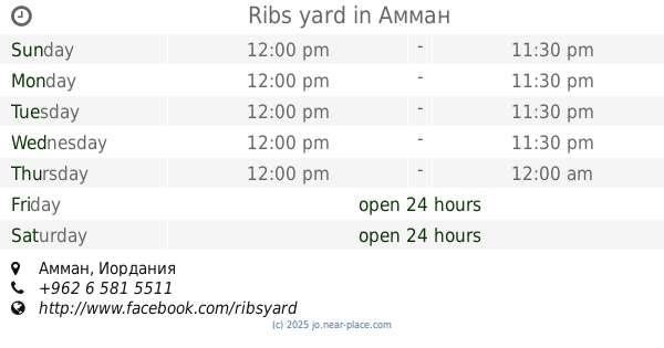
Ribs yard
Amman
Restaurant
read more
868 m
مطعم بسكاليتة
الصويفية،, Amman
Restaurant
read more
882 m
Herfly
الصويفية،, Amman
Restaurant
read more
1.006 km
QC Restaurant
Amman
Restaurant
read more
1.125 km
Shawerma wahbeh
Al-Ezz Ben Abd As-Salam Street, Amman
Restaurant
read more
1.153 km
KUHATI
Al Sahel, Amman
Restaurant
read more
1.167 km
Qadha Restaurant قدها
Al Sahel, Amman
Restaurant
read more
1.201 km
مطعم السروات دوار السابع
Al-Ezz Ben Abd As-Salam Street, Amman
Restaurant
read more
1.233 km
Tascoz Joint
Amman
Restaurant
read more
📑
all categories
Accounting
Administrative area level 1
Administrative area level 2
Airport
Amusement park
Aquarium
Art gallery
Atm
Bakery
Bank
Bar
Beauty salon
Bicycle store
Book store
Bowling alley
Bus station
Cafe
Campground
Car dealer
Car rental
Car repair
Car wash
Cemetery
Church
City hall
Clothing store
Colloquial area
Convenience store
Country
Courthouse
Dentist
Department store
Doctor
Electrician
Electronics store
Embassy
Finance
Fire station
Florist
Food
Funeral home
Furniture store
Gas station
General contractor
Grocery or supermarket
Gym
Hair care
Hardware store
Health
Home goods store
Hospital
Insurance agency
Jewelry store
Laundry
Lawyer
Library
Liquor store
Local government office
Locality
Locksmith
Lodging
Meal delivery
Meal takeaway
Mosque
Movie rental
Movie theater
Moving company
Museum
Natural feature
Neighborhood
Night club
Painter
Park
Parking
Pet store
Pharmacy
Physiotherapist
Place of worship
Plumber
Point of interest
Police
Post office
Premise
Real estate agency
Restaurant
Route
Rv park, camping
School
Shoe store
Shopping mall
Spa
Stadium
Storage
Store
Supermarket
Taxi stand
Train station
Travel agency
University
Veterinary care
Zoo
sublocality level 1
↑