Park nearby Park Greater Jerash Municipality
Coronavirus disease (COVID-19) Situation
confirmed cases
1746997
deaths
14122
Jordan
Park nearby Park Greater Jerash Municipality
Park Greater Jerash Municipality
Джараш, Иордания
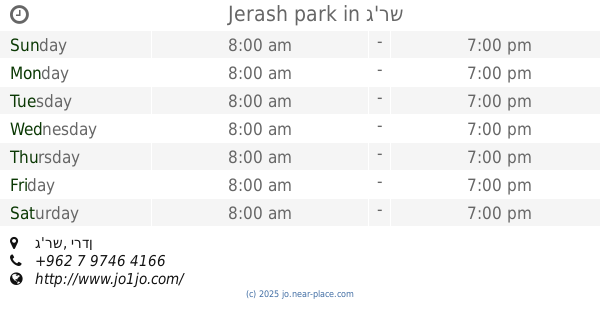
contacts phone
:
+962
Latitude:
32.2740174
, Longitude:
35.8960036
larger map & directions
read more
nearest Park
591 m
Jerash park
Jerash
Park
read more
631 m
Oval Plaza
Jerash
Park
read more
2.835 km
منتزة البركتين
Jerash
Park
read more
4.922 km
Заказник Аджлаун Форест
Ajloun, Arjaan Village, Jerash
Park
read more
6.469 km
Dibbin National Park
Jordan
Park
read more
6.469 km
Национальный парк Диббин
Jordan
Park
read more
6.637 km
منتزه دبين
Park
read more
6.677 km
House Jasmine Park
ثغرة عصفور, Jerash
Park
read more
7.38 km
Shelter will mount lighthouse protected
Jerash
Park
read more
8.835 km
Prince Hamzah Natural Reserve
Park
read more
9.086 km
محمية دبين
Park
read more
12.121 km
Royal Botanic Garden الحديقة النباتية الملكية
The Brigade of Ain Al-Basha, Jordan
Park
read more
12.739 km
Jamagh Philadelphia Park
Park
read more
14.404 km
Achtvina Park Tourism
اشتفينا, Ajloun
Park
read more
14.477 km
منتزه عجلون السياحي Ajloun Tourist Park
Ajloun
Park
read more
14.57 km
القرية الحضرية URBAN VILLAGE
Ajloun
Park
read more
17.152 km
Ajloun Forest Reserve Visitor Center
Park
read more
17.551 km
Prince Hashem Park
Park
read more
17.617 km
Ajloun Forest Reserve
Ajloun
Park
read more
20.76 km
متنزه وحديقة منشية بني حسن
Park
read more
21.383 km
The Great Zoubia Valley
Park
read more
23.848 km
Принсес Сальма Гарден
Amman
Park
read more
25.672 km
Национальный парк Зейи
Jordan
Park
read more
27.542 km
حديقة المهندس
Az-Zarqa
Park
read more
29.247 km
Park and Gardens Family
Az-Zarqa
Park
read more
📑
all categories
Accounting
Administrative area level 1
Administrative area level 2
Airport
Amusement park
Aquarium
Art gallery
Atm
Bakery
Bank
Bar
Beauty salon
Bicycle store
Book store
Bowling alley
Bus station
Cafe
Campground
Car dealer
Car rental
Car repair
Car wash
Cemetery
Church
City hall
Clothing store
Colloquial area
Convenience store
Country
Courthouse
Dentist
Department store
Doctor
Electrician
Electronics store
Embassy
Finance
Fire station
Florist
Food
Funeral home
Furniture store
Gas station
General contractor
Grocery or supermarket
Gym
Hair care
Hardware store
Health
Home goods store
Hospital
Insurance agency
Jewelry store
Laundry
Lawyer
Library
Liquor store
Local government office
Locality
Locksmith
Lodging
Meal delivery
Meal takeaway
Mosque
Movie rental
Movie theater
Moving company
Museum
Natural feature
Neighborhood
Night club
Painter
Park
Parking
Pet store
Pharmacy
Physiotherapist
Place of worship
Plumber
Point of interest
Police
Post office
Premise
Real estate agency
Restaurant
Route
Rv park, camping
School
Shoe store
Shopping mall
Spa
Stadium
Storage
Store
Supermarket
Taxi stand
Train station
Travel agency
University
Veterinary care
Zoo
sublocality level 1
↑