Neighborhood nearby Wadi Al Halabi
Jordan
Neighborhood nearby Wadi Al Halabi
Wadi Al Halabi
Wadi Al Halabi, As-Salt, ירדן
contacts phone
:
+962
Latitude:
32.0447512
, Longitude:
35.7228875
larger map & directions
read more
nearest Neighborhood
448 m
Al Maidan
Badr AjJadidah
Neighborhood
read more
462 m
Wadi Al Akrad
As-Salt
Neighborhood
read more
464 m
Al Qala'a
Badr AjJadidah
Neighborhood
read more
947 m
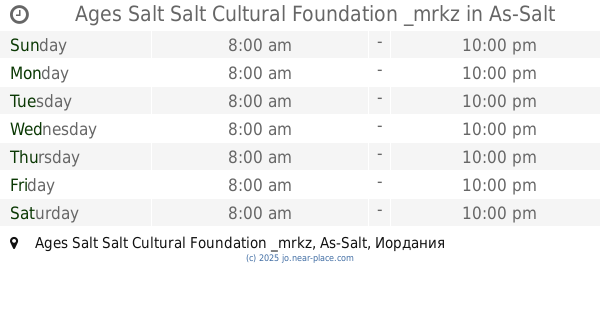
Ages Salt Salt Cultural Foundation _mrkz
Ages Salt Salt Cultural Foundation _mrkz, As-Salt
Neighborhood
read more
1.055 km
Al Jada'a
Badr AjJadidah
Neighborhood
read more
1.281 km
Al Manshieh
Badr AjJadidah
Neighborhood
read more
3.817 km
مطل شارع الستين
مطل شارع الستين, السلط
Neighborhood
read more
13.916 km
Al Salehien
Tla al-Ali
Neighborhood
read more
15.267 km
Al Jama'a
Al Jubeiha
Neighborhood
read more
16.088 km
Al Sahel
Wadi As-Seir
Neighborhood
read more
16.215 km
Al Sena'a
Wadi As-Seir
Neighborhood
read more
16.661 km
Al Swaifyeh
Wadi As-Seir
Neighborhood
read more
16.796 km
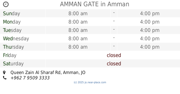
AMMAN GATE
AMMAN GATE, Queen Zain Al Sharaf Rd, Amman
Neighborhood
read more
17.216 km
Al Dmenah
Wadi As-Seir
Neighborhood
read more
17.818 km
حوض الطبقة
حوض الطبقة, منطقة مرج الحمام, عمّان
Neighborhood
read more
18.882 km
Al Thahir
Wadi As-Seir
Neighborhood
read more
19.285 km
دوار الشوابكة - الخليف
دوار الشوابكة - الخليف, عمّان
Neighborhood
read more
19.605 km
دوار البرديني - المناصير
دوار البرديني - المناصير, عمّان
Neighborhood
read more
20.536 km
دوار الاتصالات
دوار الاتصالات, عمّان
Neighborhood
read more
21.451 km
اسكان عالية
اسكان عالية, عمّان
Neighborhood
read more
21.692 km
Al Akhdar
Badr
Neighborhood
read more
22.677 km
Al Nathif
Ras al-Ain
Neighborhood
read more
22.939 km
Al Bunayyat al Janubiyah
Al Muqabalein
Neighborhood
read more
24.298 km
Umm al Kundum
Kherbat as-Souk
Neighborhood
read more
26.065 km
Al Quwaysimah
Al Qweismeh
Neighborhood
read more
📑
all categories
Accounting
Administrative area level 1
Administrative area level 2
Airport
Amusement park
Aquarium
Art gallery
Atm
Bakery
Bank
Bar
Beauty salon
Bicycle store
Book store
Bowling alley
Bus station
Cafe
Campground
Car dealer
Car rental
Car repair
Car wash
Cemetery
Church
City hall
Clothing store
Colloquial area
Convenience store
Country
Courthouse
Dentist
Department store
Doctor
Electrician
Electronics store
Embassy
Finance
Fire station
Florist
Food
Funeral home
Furniture store
Gas station
General contractor
Grocery or supermarket
Gym
Hair care
Hardware store
Health
Home goods store
Hospital
Insurance agency
Jewelry store
Laundry
Lawyer
Library
Liquor store
Local government office
Locality
Locksmith
Lodging
Meal delivery
Meal takeaway
Mosque
Movie rental
Movie theater
Moving company
Museum
Natural feature
Neighborhood
Night club
Painter
Park
Parking
Pet store
Pharmacy
Physiotherapist
Place of worship
Plumber
Point of interest
Police
Post office
Premise
Real estate agency
Restaurant
Route
Rv park, camping
School
Shoe store
Shopping mall
Spa
Stadium
Storage
Store
Supermarket
Taxi stand
Train station
Travel agency
University
Veterinary care
Zoo
sublocality level 1
↑