Mosque nearby Zubair bin Awam مسجد الزبير بن العوام
Coronavirus disease (COVID-19) Situation
confirmed cases
1746997
deaths
14122
Jordan
Mosque nearby Zubair bin Awam مسجد الزبير بن العوام
Zubair bin Awam مسجد الزبير بن العوام
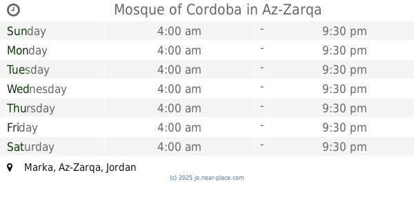
Marka, Az-Zarqa, Jordan
contacts phone
:
+962
Latitude:
32.0706861
, Longitude:
36.05157
larger map & directions
read more
nearest Mosque
408 m
مسجد عرفه
Az-Zarqa
Mosque
read more
420 m
Ruby Ben Amer Mosque
Az-Zarqa
Mosque
read more
466 m
Hamad algebra mosque
Az-Zarqa
Mosque
read more
466 m
مسجد زيد بن الحارثه
Az-Zarqa
Mosque
read more
533 m
مسجد زينب بنت الرسول
Az-Zarqa Gate, Az-Zarqa
Mosque
read more
543 m
مسجد المؤمنين
Az-Zarqa
Mosque
read more
610 m
مسجد الجبر
Az-Zarqa
Mosque
read more
719 m
مسجد الخلفاء
Az-Zarqa
Mosque
read more
806 m
مسجد مؤتة
Az-Zarqa
Mosque
read more
817 m
Aisha mosque
المدينه, المنوره،, Az-Zarqa
Mosque
read more
828 m
Khair Mosque
Army Street, Az-Zarqa
Mosque
read more
841 m
Saadi mosque
Az-Zarqa
Mosque
read more
966 m
Prophet Ismail mosque peace be upon
Az-Zarqa
Mosque
read more
975 m
مسجد النبي اسماعيل
Az-Zarqa
Mosque
read more
1.28 km
Harun Al-Rashid Mosque
Az-Zarqa
Mosque
read more
1.388 km
Mosque of Cordoba
Az-Zarqa
Mosque
read more
1.456 km
Isra Mosque
Az-Zarqa
Mosque
read more
1.486 km
Salim Jamil Ayyash Mosque
Az-Zarqa
Mosque
read more
1.511 km
Altilawy Mosque
Az-Zarqa
Mosque
read more
1.634 km
Parents of Allah Mosque
Az-Zarqa
Mosque
read more
1.682 km
Al-Falah Mosque
Unnamed Rd
Mosque
read more
1.738 km
Aweys Qarni Mosque
Az-Zarqa
Mosque
read more
1.763 km
مسجد احمد ياسين
Az-Zarqa
Mosque
read more
1.892 km
Fayhaa mosque
Az-Zarqa
Mosque
read more
2.575 km
Rahman mosque
Az-Zarqa
Mosque
read more
📑
all categories
Accounting
Administrative area level 1
Administrative area level 2
Airport
Amusement park
Aquarium
Art gallery
Atm
Bakery
Bank
Bar
Beauty salon
Bicycle store
Book store
Bowling alley
Bus station
Cafe
Campground
Car dealer
Car rental
Car repair
Car wash
Cemetery
Church
City hall
Clothing store
Colloquial area
Convenience store
Country
Courthouse
Dentist
Department store
Doctor
Electrician
Electronics store
Embassy
Finance
Fire station
Florist
Food
Funeral home
Furniture store
Gas station
General contractor
Grocery or supermarket
Gym
Hair care
Hardware store
Health
Home goods store
Hospital
Insurance agency
Jewelry store
Laundry
Lawyer
Library
Liquor store
Local government office
Locality
Locksmith
Lodging
Meal delivery
Meal takeaway
Mosque
Movie rental
Movie theater
Moving company
Museum
Natural feature
Neighborhood
Night club
Painter
Park
Parking
Pet store
Pharmacy
Physiotherapist
Place of worship
Plumber
Point of interest
Police
Post office
Premise
Real estate agency
Restaurant
Route
Rv park, camping
School
Shoe store
Shopping mall
Spa
Stadium
Storage
Store
Supermarket
Taxi stand
Train station
Travel agency
University
Veterinary care
Zoo
sublocality level 1
↑