Local government office nearby Ajloun Civil Defense
Jordan
Local government office nearby Ajloun Civil Defense
Ajloun Civil Defense
Ajloun, ירדן
contacts phone
:
+962
Latitude:
32.3590765
, Longitude:
35.7825445
larger map & directions
read more
nearest Local government office
4.768 km
الارشاد الزراعي
Ajloun
Local government office
read more
4.876 km
مبنى محافظة عجلون
Ajloun
Local government office
read more
8.217 km
Zoubia Municipality
Local government office
read more
9.066 km
Faisal Ahmed Bani Melhem
Local government office
read more
13.09 km
Jarash City Police Station
Jerash
Local government office
read more
13.248 km
Jarash Court
Jerash
Local government office
read more
13.278 km
مديرية شرطة جرش
Jerash
Local government office
read more
13.579 km
ادارة محافظة جرش
Jerash
Local government office
read more
13.633 km
مديرية التربية والتعليم للواء المزار الشمالي
Local government office
read more
13.741 km
بلديه جرش الكبرى
Jerash
Local government office
read more
14.531 km
قاعة بلدية جرش الكبرى
Jerash
Local government office
read more
15.013 km
بلدية حوفا المزار
Local government office
read more
15.159 km
ادارة ترخيص السواقين والمركبات جرش
Jerash
Local government office
read more
17.443 km
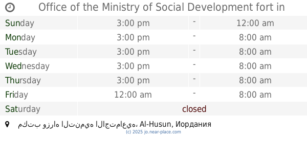
Office of the Ministry of Social Development fort
مكتب وزراه التنميه الاجتماعيه, Al-Husun
Local government office
read more
19.017 km
Driver and Vehicle Licensing Department
As-Sarih
Local government office
read more
19.339 km
Aidun إيدون
Local government office
read more
19.771 km
Tabqat Fahel Municipality
Local government office
read more
22.951 km
المغفر الشرقي
Irbid
Local government office
read more
23.023 km
Tbaishat Family Diwan - Al Khalaf
Irbid
Local government office
read more
23.03 km
Tbaishat Family Diwan - Al Sihaiman
Irbid
Local government office
read more
23.051 km
Diwan Al-Kofahi
32°33'42. 35°50'00., Jordan Lane 9, Bentonville
Local government office
read more
23.58 km
المركز الوطني للبحث والارشاد الزراعي اربد
Ramtha
Local government office
read more
23.714 km
مركز الشلل الدماغي
Irbid
Local government office
read more
24.246 km
Tbaishat Family Diwan - Al Ismail
Karachi Street, Irbid
Local government office
read more
29.964 km
Chapel Licensing Center
Ramtha
Local government office
read more
📑
all categories
Accounting
Administrative area level 1
Administrative area level 2
Airport
Amusement park
Aquarium
Art gallery
Atm
Bakery
Bank
Bar
Beauty salon
Bicycle store
Book store
Bowling alley
Bus station
Cafe
Campground
Car dealer
Car rental
Car repair
Car wash
Cemetery
Church
City hall
Clothing store
Colloquial area
Convenience store
Country
Courthouse
Dentist
Department store
Doctor
Electrician
Electronics store
Embassy
Finance
Fire station
Florist
Food
Funeral home
Furniture store
Gas station
General contractor
Grocery or supermarket
Gym
Hair care
Hardware store
Health
Home goods store
Hospital
Insurance agency
Jewelry store
Laundry
Lawyer
Library
Liquor store
Local government office
Locality
Locksmith
Lodging
Meal delivery
Meal takeaway
Mosque
Movie rental
Movie theater
Moving company
Museum
Natural feature
Neighborhood
Night club
Painter
Park
Parking
Pet store
Pharmacy
Physiotherapist
Place of worship
Plumber
Point of interest
Police
Post office
Premise
Real estate agency
Restaurant
Route
Rv park, camping
School
Shoe store
Shopping mall
Spa
Stadium
Storage
Store
Supermarket
Taxi stand
Train station
Travel agency
University
Veterinary care
Zoo
sublocality level 1
↑