Gas station nearby مستودعات الغاز الهنانده
Jordan
Gas station nearby مستودعات الغاز الهنانده
مستودعات الغاز الهنانده
Gobernación de Zarká, Jordania
contacts phone
:
+962 7 9513 3697
Latitude:
32.1369372
, Longitude:
36.16793
larger map & directions
read more
nearest Gas station
4.637 km
Jo Petrol Petrol Station
Damascus Highway
Gas station
read more
4.735 km
Dara Petrol Station
Gas station
read more
4.791 km
شركة مصفاة البترول الاردنية
25
Gas station
read more
5.577 km
Al-Manaseer Gas Station
Damascus Highway, Dhlail
Gas station
read more
5.654 km
Al-Zyoud Gas Station
Gas station
read more
5.69 km
محطة دبلان الحديثة للمحروقات
Gas station
read more
6.017 km
Hashemite - blue
Gas station
read more
6.154 km
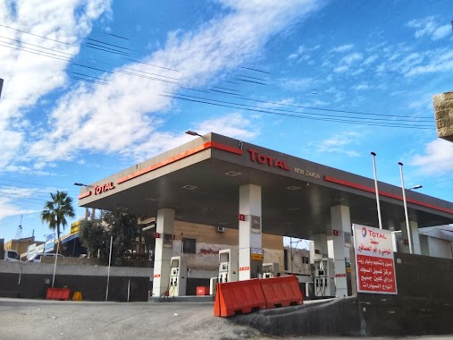
Тотал
Damascus Hwy, Az-Zarqa
Gas station
read more
6.464 km
محطة بوابة الشمال للمحروقات
Gas station
read more
6.585 km
Servants Rahman Car Service Station and the publisher of the uniform parts
الهاشمية الجنوبية،, Az-Zarqa
Gas station
read more
8.291 km
پمپ بنزین
الضليل شارع الجيش
Gas station
read more
8.723 km
Gas Station Twenty-six
Az-Zarqa
Gas station
read more
9.497 km
Abu Saleh, a fuel station
Gas station
read more
9.709 km
Total Petrol Station 36
Az-Zarqa
Gas station
read more
10.051 km
Oil petrol station Joe
Az-Zarqa
Gas station
read more
10.929 km
People Petrol Station
Az-Zarqa
Gas station
read more
11.009 km
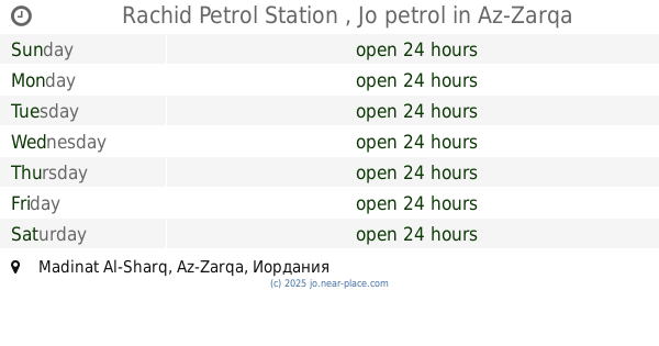
Rachid Petrol Station , Jo petrol
Az-Zarqa
Gas station
read more
12.098 km
Shreim Total Station section II
Az-Zarqa
Gas station
read more
12.126 km
كازية الحسبان alhosban gas station
Gas station
read more
12.203 km
محطة بن سرداح
Az-Zarqa
Gas station
read more
12.827 km
Petrol Station
Az-Zarqa
Gas station
read more
12.852 km
JO Petrol
Az-Zarqa
Gas station
read more
16.507 km
Тотал
K. Hussein St., Russayfah, Az-Zarqa
Gas station
read more
16.644 km
Shreim Gas Station/محطة شريم للمحروقات الفرع الرئيسي
Army Street, Russayfah
Gas station
read more
19.582 km
محطة وقود Jopetrol
لواء الرصيفة،, Russayfah
Gas station
read more
📑
all categories
Accounting
Administrative area level 1
Administrative area level 2
Airport
Amusement park
Aquarium
Art gallery
Atm
Bakery
Bank
Bar
Beauty salon
Bicycle store
Book store
Bowling alley
Bus station
Cafe
Campground
Car dealer
Car rental
Car repair
Car wash
Cemetery
Church
City hall
Clothing store
Colloquial area
Convenience store
Country
Courthouse
Dentist
Department store
Doctor
Electrician
Electronics store
Embassy
Finance
Fire station
Florist
Food
Funeral home
Furniture store
Gas station
General contractor
Grocery or supermarket
Gym
Hair care
Hardware store
Health
Home goods store
Hospital
Insurance agency
Jewelry store
Laundry
Lawyer
Library
Liquor store
Local government office
Locality
Locksmith
Lodging
Meal delivery
Meal takeaway
Mosque
Movie rental
Movie theater
Moving company
Museum
Natural feature
Neighborhood
Night club
Painter
Park
Parking
Pet store
Pharmacy
Physiotherapist
Place of worship
Plumber
Point of interest
Police
Post office
Premise
Real estate agency
Restaurant
Route
Rv park, camping
School
Shoe store
Shopping mall
Spa
Stadium
Storage
Store
Supermarket
Taxi stand
Train station
Travel agency
University
Veterinary care
Zoo
sublocality level 1
↑