Gas station nearby محطة وقود الشقران
Jordan
Gas station nearby محطة وقود الشقران
محطة وقود الشقران
Unnamed Road, Ramtha ישראל
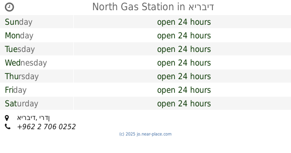
contacts phone
:
+962
Latitude:
32.5692952
, Longitude:
35.9791189
read more
nearest Gas station
15 m
محطة وقود الشقران
Ramtha
Gas station
read more
3.412 km
كازية الشرع
Ramtha
Gas station
read more
3.638 km
محطة توتال
Ramtha
Gas station
read more
5.839 km
Тотал
Ramtha, Amman
Gas station
read more
5.935 km
Gas Station nughayr
Gas station
read more
6.433 km
Sal fuel station
Sal
Gas station
read more
6.585 km
محطة أردن الحديثة للمحروقات
Ramtha
Gas station
read more
7.027 km
محطة وقود الطرة Gulf
King Hussein, At Turrah, 21310,, Irbid
Gas station
read more
7.739 km
Total
Ramtha
Gas station
read more
8.906 km
Bushra Gas Station
Bushra
Gas station
read more
9.177 km
محطة الشجرة للمحروقات
Ash-Shajarah
Gas station
read more
9.199 km
Atheer Gas Station
Irbid
Gas station
read more
9.463 km
University of Science Station
Ramtha
Gas station
read more
10.28 km
مركز اربد لخدمه غيار الزيت والبناشر
شارع بشرى،، إربد
Gas station
read more
10.345 km
كراج العمري عمرالعمري
Irbid
Gas station
read more
10.747 km
Abu Bakr Petrol Station
Irbid
Gas station
read more
10.973 km
محطة توتال للمحروقات TOTAL Petrol Station
Irbid
Gas station
read more
11.086 km
محطة الخال للمحروقات
Irbid
Gas station
read more
11.388 km
Total Petrol Station
Irbid Qasabah District, Irbid
Gas station
read more
11.56 km
North Station Irbid
An-Nour Street, Irbid
Gas station
read more
12.141 km
Ashour Gas Station
25
Gas station
read more
13.145 km
North Gas Station
Gas station
read more
13.145 km
محطة الشمال الحديثة للمحروقات
Bani Obeid District، Amman irbid highway، Irbid
Gas station
read more
13.21 km
Total
Irbid
Gas station
read more
18.236 km
محطة حرثا للمحروقات
Gas station
read more
📑
all categories
Accounting
Administrative area level 1
Administrative area level 2
Airport
Amusement park
Aquarium
Art gallery
Atm
Bakery
Bank
Bar
Beauty salon
Bicycle store
Book store
Bowling alley
Bus station
Cafe
Campground
Car dealer
Car rental
Car repair
Car wash
Cemetery
Church
City hall
Clothing store
Colloquial area
Convenience store
Country
Courthouse
Dentist
Department store
Doctor
Electrician
Electronics store
Embassy
Finance
Fire station
Florist
Food
Funeral home
Furniture store
Gas station
General contractor
Grocery or supermarket
Gym
Hair care
Hardware store
Health
Home goods store
Hospital
Insurance agency
Jewelry store
Laundry
Lawyer
Library
Liquor store
Local government office
Locality
Locksmith
Lodging
Meal delivery
Meal takeaway
Mosque
Movie rental
Movie theater
Moving company
Museum
Natural feature
Neighborhood
Night club
Painter
Park
Parking
Pet store
Pharmacy
Physiotherapist
Place of worship
Plumber
Point of interest
Police
Post office
Premise
Real estate agency
Restaurant
Route
Rv park, camping
School
Shoe store
Shopping mall
Spa
Stadium
Storage
Store
Supermarket
Taxi stand
Train station
Travel agency
University
Veterinary care
Zoo
sublocality level 1
↑