Gas station nearby Karameh Petrol Station
Coronavirus disease (COVID-19) Situation
confirmed cases
1746997
deaths
14122
Jordan
Gas station nearby Karameh Petrol Station
Karameh Petrol Station
מחוז בלקא, ירדן
contacts phone
:
+962
Latitude:
31.9486278
, Longitude:
35.5806529
larger map & directions
read more
nearest Gas station
7 m
KARAMEH Petrol Station
Karameh
Gas station
read more
6.389 km
Jet Gas Station
Gas station
read more
10.717 km
Jawasrh triangle
مثلث الجواسرة
Gas station
read more
16.639 km
محطة المناصير للمحروقات
Gas station
read more
16.792 km
محطة المناصير للمحروقات
65
Gas station
read more
17.456 km
Fendi Petrol Station
As-Salt
Gas station
read more
18.916 km
Saleh Abu Teen Gaz Station Co. Dead Sea
Jordan Valley Highway Governorate, Aqaba
Gas station
read more
19.293 km
محطة وقود زي TOTAL
As-Salt
Gas station
read more
19.294 km
total gas station. near zayi
As-Salt
Gas station
read more
19.91 km
JPPMC
As-Salt
Gas station
read more
21.624 km
Valleys modern fuel station
Gas station
read more
21.912 km
Total (توتال)
Jordan
Gas station
read more
22.087 km
MANASERR GAS STATION
Balqa
Gas station
read more
23.989 km
مركز الرحمة لصيانة الهايبرد
Amman
Gas station
read more
24.305 km
Total Petrol Station
Amman
Gas station
read more
24.48 km
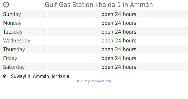
Gulf Gas Station khalda 1
Amman
Gas station
read more
24.564 km
Oil express
Muhammad Ad-Daajah Street, Amman
Gas station
read more
24.883 km
Manaseer Oil & Gas
Manaseer Oil & Gas, Al Sinaah St 32, Amman
Gas station
read more
25.819 km
كازية السلام
Amman
Gas station
read more
26.138 km
Total Sweileh Circle - توتال دوار صويلح
Rashid Abu Remman، Sweileh
Gas station
read more
26.244 km
كراج ابوشاويش للمكانيك
Gas station
read more
27.587 km
JOPETROL GAS STATION
Jordan
Gas station
read more
27.598 km
پمپ بنزین
Balqa
Gas station
read more
29.12 km
Jo Petrol Gas Station
Gas station
read more
33.143 km
Total Gas Station
Madaba
Gas station
read more
📑
all categories
Accounting
Administrative area level 1
Administrative area level 2
Airport
Amusement park
Aquarium
Art gallery
Atm
Bakery
Bank
Bar
Beauty salon
Bicycle store
Book store
Bowling alley
Bus station
Cafe
Campground
Car dealer
Car rental
Car repair
Car wash
Cemetery
Church
City hall
Clothing store
Colloquial area
Convenience store
Country
Courthouse
Dentist
Department store
Doctor
Electrician
Electronics store
Embassy
Finance
Fire station
Florist
Food
Funeral home
Furniture store
Gas station
General contractor
Grocery or supermarket
Gym
Hair care
Hardware store
Health
Home goods store
Hospital
Insurance agency
Jewelry store
Laundry
Lawyer
Library
Liquor store
Local government office
Locality
Locksmith
Lodging
Meal delivery
Meal takeaway
Mosque
Movie rental
Movie theater
Moving company
Museum
Natural feature
Neighborhood
Night club
Painter
Park
Parking
Pet store
Pharmacy
Physiotherapist
Place of worship
Plumber
Point of interest
Police
Post office
Premise
Real estate agency
Restaurant
Route
Rv park, camping
School
Shoe store
Shopping mall
Spa
Stadium
Storage
Store
Supermarket
Taxi stand
Train station
Travel agency
University
Veterinary care
Zoo
sublocality level 1
↑