Cafe nearby تفاحتين كافيه
Jordan
Cafe nearby تفاحتين كافيه
تفاحتين كافيه
7th Circle, Amman, JO Jordan
contacts phone
:
+962
Latitude:
31.9563133
, Longitude:
35.8553316
larger map & directions
read more
nearest Cafe
37 m
Selle di Cavalli Cafe
31.956003,855205, 35
Cafe
read more
110 m
Alaseel Café
Amman
Cafe
read more
165 m
MON CHOU Frensh Pastries
30, 22, Saleh As-Samadi Street, Amman
Cafe
read more
195 m
مطعم و كافيه صهلله
Unnamed Road, Amman
Cafe
read more
236 m
Wheelys Cafe
Princess Sumayya, Fatemah Bent Al-Hasan Street, Amman
Cafe
read more
251 m
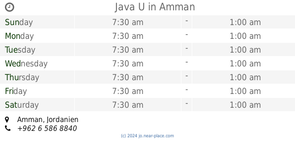
Java U
Amman
Cafe
read more
266 m
Wade3 Zamman Restaurant & Cafe مقهى وديع زمان
Princess Sumayah Bent Al-Hasan Street, Amman
Cafe
read more
348 m
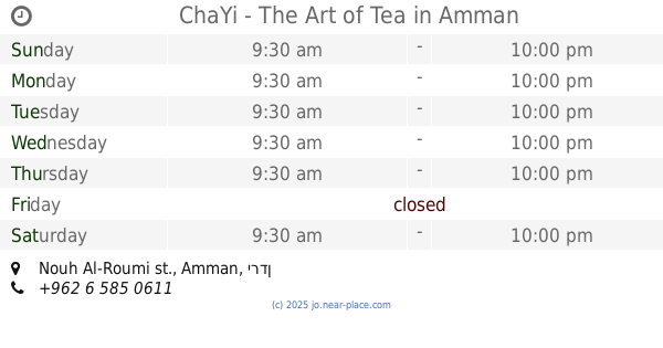
ChaYi - The Art of Tea
Nouh Al-Roumi st.
Cafe
read more
386 m
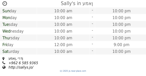
Sally's
Amman
Cafe
read more
390 m
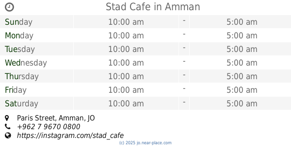
Stad Cafe
Paris Street, Amman
Cafe
read more
397 m
مقهى چاي خانة
Paris Street 17, Amman
Cafe
read more
497 m
Nas w Nas
Wakalat, Amman
Cafe
read more
501 m
قهوة زغللة
At-Tabashir Street, Amman
Cafe
read more
504 m
اهوة كوتشينا
Abd Ar-Rahman Khalifah St, Amman
Cafe
read more
504 m
Helium هيليوم
Amman
Cafe
read more
589 m
Violet Restaurant and Cafe
Yanabe Str
Cafe
read more
728 m
Zain Cafe
Amman
Cafe
read more
745 m
Raqmu Coffee House
Yazid Al-Asadi Street, Amman
Cafe
read more
769 m
حلويات حبيبة الصويفية
Amman
Cafe
read more
838 m
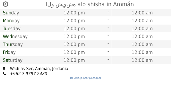
الو شيشه alo shisha
Amman
Cafe
read more
932 m
The Coffee Bean & Tea Leaf 5
Massoud Ben Saed Street, Amman
Cafe
read more
957 m
Bin Izheiman بن ازحيمان
Sobhi Al-Omari Street 20, Amman
Cafe
read more
1.232 km
Syrian Bakery
Amman
Cafe
read more
1.255 km
Starbucks
Naqib Omran Al-Maayetah Street, Amman
Cafe
read more
1.294 km
B&D Cafe
Naqib Omran Al-Maayetah Street, Amman
Cafe
read more
📑
all categories
Accounting
Administrative area level 1
Administrative area level 2
Airport
Amusement park
Aquarium
Art gallery
Atm
Bakery
Bank
Bar
Beauty salon
Bicycle store
Book store
Bowling alley
Bus station
Cafe
Campground
Car dealer
Car rental
Car repair
Car wash
Cemetery
Church
City hall
Clothing store
Colloquial area
Convenience store
Country
Courthouse
Dentist
Department store
Doctor
Electrician
Electronics store
Embassy
Finance
Fire station
Florist
Food
Funeral home
Furniture store
Gas station
General contractor
Grocery or supermarket
Gym
Hair care
Hardware store
Health
Home goods store
Hospital
Insurance agency
Jewelry store
Laundry
Lawyer
Library
Liquor store
Local government office
Locality
Locksmith
Lodging
Meal delivery
Meal takeaway
Mosque
Movie rental
Movie theater
Moving company
Museum
Natural feature
Neighborhood
Night club
Painter
Park
Parking
Pet store
Pharmacy
Physiotherapist
Place of worship
Plumber
Point of interest
Police
Post office
Premise
Real estate agency
Restaurant
Route
Rv park, camping
School
Shoe store
Shopping mall
Spa
Stadium
Storage
Store
Supermarket
Taxi stand
Train station
Travel agency
University
Veterinary care
Zoo
sublocality level 1
↑