Cafe nearby قهوة أبو زايد أحمد
Coronavirus disease (COVID-19) Situation
confirmed cases
1746997
deaths
14122
Jordan
Cafe nearby قهوة أبو زايد أحمد
قهوة أبو زايد أحمد
Ad-Dustour Street 29, Amman Israel
contacts phone
:
+962
Latitude:
31.9392225
, Longitude:
35.9207575
read more
nearest Cafe
66 m
قهوة الشلش 1
Ad-Dustour Street, Amman
Cafe
read more
412 m
Jasser Tawfiq Coffee
Ad-Dustour Street, Amman
Cafe
read more
462 m
قهوة الصقر
Ad-Dustour Street 77, Amman
Cafe
read more
568 m
قهوة ابو حلوة
Ad-Dustour Street, Amman
Cafe
read more
693 m
بن نكهة فنجان
NazzAl-Al-Armouti Street, Amman
Cafe
read more
769 m
كافتريا سعود التعمري
Al-Karak Street 48،, Amman
Cafe
read more
991 m
Latino di Roma
Arajan، عمّان
Cafe
read more
997 m
Yahya Cafeteria
Complex No 63, Al Natheef St 63, Amman
Cafe
read more
1.027 km
Salam Kanaan Gallery
Taher Al Juqqah street 100, Amman
Cafe
read more
1.226 km
Tonnerre
Taher Al Juqqah street 39, Amman
Cafe
read more
1.344 km
Makkan Cafe
Amman
Cafe
read more
1.508 km
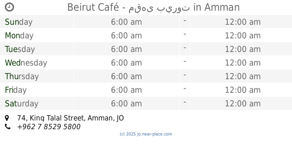
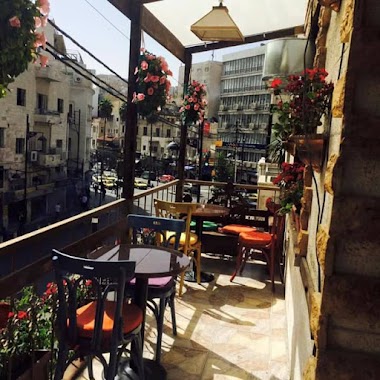
Beirut Café - مقهى بيروت
King Talal Street 74, Amman
Cafe
read more
1.539 km
Kiswani Coffee
Al Thra', Amman
Cafe
read more
1.611 km
Abu Sultan Cafe
Prince Muhammad Street, Amman
Cafe
read more
1.757 km
Al Sharbati Cafeteria
Kherfan Complex, Basman Street 31, Amman
Cafe
read more
1.801 km
A'amoun Café
KIng Faysal Square, Amman
Cafe
read more
1.809 km
قهوة عمون
Amman
Cafe
read more
1.832 km
Romana Coffee
KIng Faysal Square, Amman
Cafe
read more
1.841 km
Hikayat Al Balad Cafe مقهى حكايات البلد
King Hussein Street, Amman
Cafe
read more
1.854 km
Cafe memories of the country
King Hussein Street, Amman
Cafe
read more
1.945 km
Qerfeh قرفة
Amman
Cafe
read more
1.947 km
Hade dondurma coffe bar
Amman
Cafe
read more
2.144 km
FUN NETWORK GAMES
Amman
Cafe
read more
2.181 km
مقهى قلب عمان
Al-Hashemi Street 55, Amman
Cafe
read more
2.249 km
Refreshments and Coffee Shop
Amman
Cafe
read more
📑
all categories
Accounting
Administrative area level 1
Administrative area level 2
Airport
Amusement park
Aquarium
Art gallery
Atm
Bakery
Bank
Bar
Beauty salon
Bicycle store
Book store
Bowling alley
Bus station
Cafe
Campground
Car dealer
Car rental
Car repair
Car wash
Cemetery
Church
City hall
Clothing store
Colloquial area
Convenience store
Country
Courthouse
Dentist
Department store
Doctor
Electrician
Electronics store
Embassy
Finance
Fire station
Florist
Food
Funeral home
Furniture store
Gas station
General contractor
Grocery or supermarket
Gym
Hair care
Hardware store
Health
Home goods store
Hospital
Insurance agency
Jewelry store
Laundry
Lawyer
Library
Liquor store
Local government office
Locality
Locksmith
Lodging
Meal delivery
Meal takeaway
Mosque
Movie rental
Movie theater
Moving company
Museum
Natural feature
Neighborhood
Night club
Painter
Park
Parking
Pet store
Pharmacy
Physiotherapist
Place of worship
Plumber
Point of interest
Police
Post office
Premise
Real estate agency
Restaurant
Route
Rv park, camping
School
Shoe store
Shopping mall
Spa
Stadium
Storage
Store
Supermarket
Taxi stand
Train station
Travel agency
University
Veterinary care
Zoo
sublocality level 1
↑