Cafe nearby مقهى خيمة دير القمر
Jordan
Cafe nearby مقهى خيمة دير القمر
مقهى خيمة دير القمر
Al Abdali, Amman, ירדן
contacts phone
:
+962 7 9038 1241
Latitude:
31.9893216
, Longitude:
35.9128891
larger map & directions
read more
nearest Cafe
234 m
Qasr Al Rasheed international Cafe
Qasr Al Rasheed international Cafe, Al Shaheed St 129, Amman
Cafe
read more
282 m
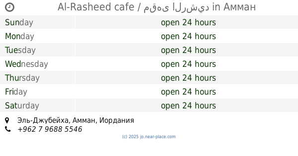
Al-Rasheed cafe / مقهى الرشيد
Amman
Cafe
read more
683 m
Vivian Cafe'
Amman
Cafe
read more
891 m
Magic Eye - العين السحرية
Amman
Cafe
read more
893 m
Chalenge for gaming
Amman
Cafe
read more
913 m
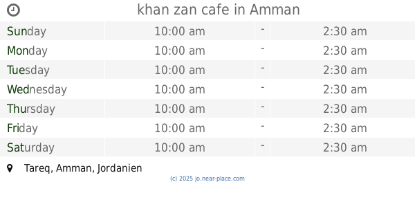
khan zan cafe
Amman
Cafe
read more
915 m
Jordan Original Vape
Amman
Cafe
read more
1.266 km
مركز جمال عطية للبلياردو والسنوكر
Al-Qussai Street, Amman
Cafe
read more
1.313 km
قهوة بشر
As-Sultan Qalaoun Street 39،, Amman
Cafe
read more
1.457 km
Mtal mlka 3lia
Amman
Cafe
read more
1.458 km
قهوة العراب
الجرن،, Amman
Cafe
read more
1.608 km
مقهى التمبكجي | Altembakji
Amman
Cafe
read more
1.68 km
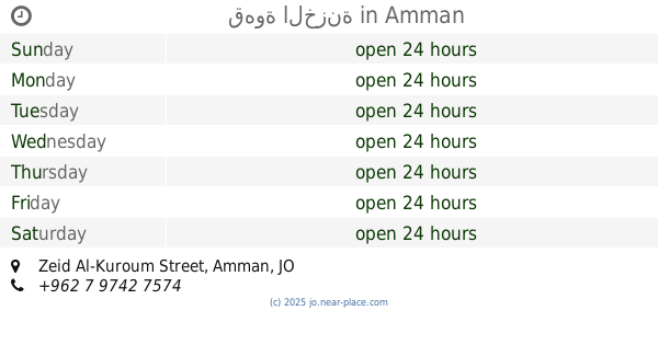
قهوة الخزنة
Zeid Al-Kuroum Street, Amman
Cafe
read more
1.712 km
كفتيريا دقة الهاون
Al-Sharif Naser Ben Jamil Street 157, Amman
Cafe
read more
1.715 km
Lemar Cafe
Akad Commercial Complex, Queen Rania Al Abdullah St 34, Amman
Cafe
read more
1.76 km
ليمون و نعنع للتدخين
Al-Jereishah Street, Amman
Cafe
read more
1.863 km
Al Shareef Coffee Shop
Adnan Hussein Complex, Queen Rania Al Abdullah St 44, Amman
Cafe
read more
1.863 km
الحريف
Al-Sharif Naser Ben Jamil Street 141, Amman
Cafe
read more
1.961 km
العميد للقهوة العربية
Amman
Cafe
read more
1.995 km
Coffee Zone
Wasfi At-Tall Street 1, Amman
Cafe
read more
2 km
Hamdan Cafe
Ghazi Arabeyat Street, Amman
Cafe
read more
2.032 km
Champions PlayStation Center
Ar-Rawdah Street 28, Amman
Cafe
read more
2.044 km
Jazeera Club
Ghazi Arabeyat Street, Amman
Cafe
read more
2.205 km
Hotel Nefertiti فندق نفرتيتي
26 Al-Jahedh Str., Al-Shmeisani, Amman
Cafe
read more
2.242 km
The Qyard
Amman
Cafe
read more
📑
all categories
Accounting
Administrative area level 1
Administrative area level 2
Airport
Amusement park
Aquarium
Art gallery
Atm
Bakery
Bank
Bar
Beauty salon
Bicycle store
Book store
Bowling alley
Bus station
Cafe
Campground
Car dealer
Car rental
Car repair
Car wash
Cemetery
Church
City hall
Clothing store
Colloquial area
Convenience store
Country
Courthouse
Dentist
Department store
Doctor
Electrician
Electronics store
Embassy
Finance
Fire station
Florist
Food
Funeral home
Furniture store
Gas station
General contractor
Grocery or supermarket
Gym
Hair care
Hardware store
Health
Home goods store
Hospital
Insurance agency
Jewelry store
Laundry
Lawyer
Library
Liquor store
Local government office
Locality
Locksmith
Lodging
Meal delivery
Meal takeaway
Mosque
Movie rental
Movie theater
Moving company
Museum
Natural feature
Neighborhood
Night club
Painter
Park
Parking
Pet store
Pharmacy
Physiotherapist
Place of worship
Plumber
Point of interest
Police
Post office
Premise
Real estate agency
Restaurant
Route
Rv park, camping
School
Shoe store
Shopping mall
Spa
Stadium
Storage
Store
Supermarket
Taxi stand
Train station
Travel agency
University
Veterinary care
Zoo
sublocality level 1
↑