Cafe nearby القهوة الكيفية
Coronavirus disease (COVID-19) Situation
confirmed cases
1746997
deaths
14122
Jordan
Cafe nearby القهوة الكيفية
القهوة الكيفية
دوار النعيمات، ام السماق، عمّان،، Иордания
contacts phone
:
+962 7 9147 8591
Latitude:
31.9816856
, Longitude:
35.8434314
larger map & directions
read more
nearest Cafe
403 m
قهوة ابو صالح
Amman
Cafe
read more
427 m
Caffe Vergnano 1882 - Mecca Mall
Mecca Mall, Abdullah Al Dawoud St 20, Amman
Cafe
read more
437 m
STARBUCKS COFFEE
Mecca Mall, Amman
Cafe
read more
514 m
Azul Coffee House
Mecca st, Gate 1, Ground Floor, Mecca Mall,, Amman
Cafe
read more
573 m
Caffe Hanin - كافيه حنين
Amman
Cafe
read more
580 m
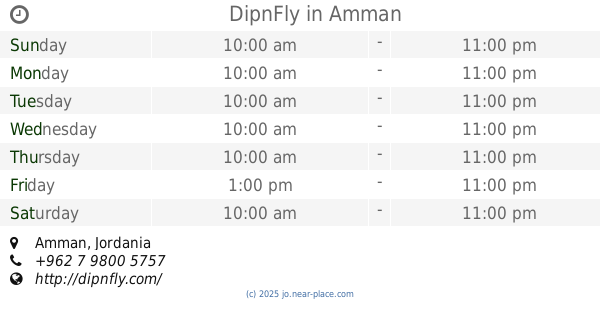
DipnFly
Amman
Cafe
read more
597 m
x station
Amir Ben Malek Street, Amman
Cafe
read more
635 m
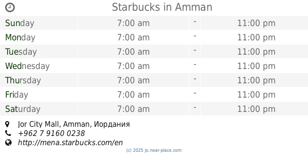
Starbucks
Jor City Mall, Amman
Cafe
read more
871 m
Dimitri's Coffee
Mamdouh al Sarayra St، عمّان
Cafe
read more
893 m
Olibol Donuts
Mamdouh As-Sarirah Street, Amman
Cafe
read more
893 m
Olibol Donuts
Mamdouh Al-Sarayrah Street, Amman
Cafe
read more
903 m
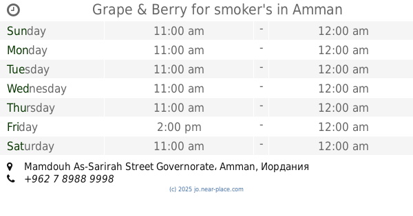
Grape & Berry for smoker's
Mamdouh As-Sarirah Street Governorate, Amman
Cafe
read more
912 m
مقهى الباشا
Mamdouh As-Sarirah Street, Amman
Cafe
read more
916 m
Ahwitna Cafe
Amman
Cafe
read more
925 m
AlFalamanki
Amman
Cafe
read more
969 m
The Squad
Mamdouh Al-Sarayrah Street, Street
Cafe
read more
990 m
Stickhouse Jordan
Al Rawabi, Amman
Cafe
read more
1.053 km
Down Town coffee (قهوة وسط المدينة)
Amman
Cafe
read more
1.057 km
Ramsees Cafe
Mecca Street 186, Amman
Cafe
read more
1.07 km
Saleem Coffee
maca.st
Cafe
read more
1.07 km
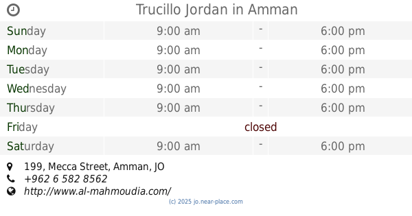
Trucillo Jordan
Mecca Street 199, Amman
Cafe
read more
1.081 km
Rewayat Cafe
Jaber complex, Mecca street, Amman
Cafe
read more
1.085 km
Karakeeb Cafe
Amman
Cafe
read more
1.121 km
صالون العراب
Unnamed, Al Hezam Road, Amman
Cafe
read more
1.173 km
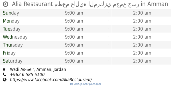
Alia Restsurant مطعم عالية المركزي مجمع جبر
Amman
Cafe
read more
📑
all categories
Accounting
Administrative area level 1
Administrative area level 2
Airport
Amusement park
Aquarium
Art gallery
Atm
Bakery
Bank
Bar
Beauty salon
Bicycle store
Book store
Bowling alley
Bus station
Cafe
Campground
Car dealer
Car rental
Car repair
Car wash
Cemetery
Church
City hall
Clothing store
Colloquial area
Convenience store
Country
Courthouse
Dentist
Department store
Doctor
Electrician
Electronics store
Embassy
Finance
Fire station
Florist
Food
Funeral home
Furniture store
Gas station
General contractor
Grocery or supermarket
Gym
Hair care
Hardware store
Health
Home goods store
Hospital
Insurance agency
Jewelry store
Laundry
Lawyer
Library
Liquor store
Local government office
Locality
Locksmith
Lodging
Meal delivery
Meal takeaway
Mosque
Movie rental
Movie theater
Moving company
Museum
Natural feature
Neighborhood
Night club
Painter
Park
Parking
Pet store
Pharmacy
Physiotherapist
Place of worship
Plumber
Point of interest
Police
Post office
Premise
Real estate agency
Restaurant
Route
Rv park, camping
School
Shoe store
Shopping mall
Spa
Stadium
Storage
Store
Supermarket
Taxi stand
Train station
Travel agency
University
Veterinary care
Zoo
sublocality level 1
↑