Cafe nearby الخال كافيه alkhal café
Coronavirus disease (COVID-19) Situation
confirmed cases
1746997
deaths
14122
Jordan
Cafe nearby الخال كافيه alkhal café
الخال كافيه alkhal café
אירביד, ירדן
contacts phone
:
+962
Latitude:
32.544932
, Longitude:
35.8583564
larger map & directions
read more
nearest Cafe
23 m
كرمنا كافيه
اربد دوار القبة, Feras Al-Ajlouni Street, Irbid
Cafe
read more
46 m
Zatara Cafe
Irbid
Cafe
read more
71 m
قهوة أبو العز
محطة المناصير للمحروقات
Cafe
read more
153 m
بن العربي
Irbid
Cafe
read more
436 m
An hour for your heart
Unnamed Road,, Irbid
Cafe
read more
516 m
Olympus Gaming Center
Irbid
Cafe
read more
524 m
alrokon
Abdul Qader At-Tal Street, Irbid
Cafe
read more
526 m
Al-rokn
Abdul Qader At-Tal Street, Irbid
Cafe
read more
529 m
Alrokon 1439
Abdul Qader At-Tal Street, Irbid
Cafe
read more
562 m
قهوة الرفاعي
Irbid
Cafe
read more
573 m
اراجيل ومعسل
Irbid
Cafe
read more
687 m
Nesquik Cafe
35, Irbid
Cafe
read more
779 m
Osmanli Cafe
Irbid
Cafe
read more
874 m
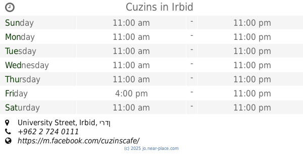
Cuzins
University Street, Irbid
Cafe
read more
958 m
Nescafe
University Street, Irbid
Cafe
read more
965 m
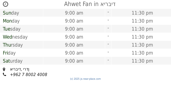
Ahwet Fan
Irbid
Cafe
read more
970 m
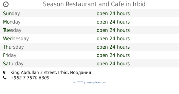
Season Restaurant and Cafe
King Abdullah 2 street, Irbid
Cafe
read more
981 m
قهوة أبو صبح
Irbid
Cafe
read more
1.004 km
Banana Cafe
Irbid
Cafe
read more
1.046 km
قهوة العتوم
Tolkarem Street, Irbid
Cafe
read more
1.048 km
Cafe Alcazar
Irbid
Cafe
read more
1.1 km
Bizantino Coffee Roaster محمص بن البيزنطي
Unnamed Road, Irbid
Cafe
read more
1.111 km
Bubbles & Waffles
Al-Basrah Street, Irbid
Cafe
read more
1.143 km
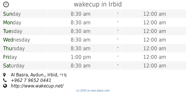
wakecup
Al Basra, Aydun,, Irbid
Cafe
read more
1.178 km
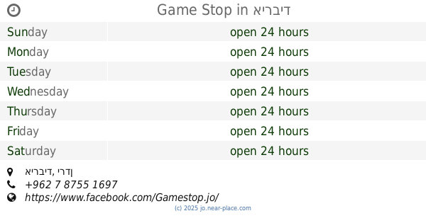
Game Stop
Irbid
Cafe
read more
📑
all categories
Accounting
Administrative area level 1
Administrative area level 2
Airport
Amusement park
Aquarium
Art gallery
Atm
Bakery
Bank
Bar
Beauty salon
Bicycle store
Book store
Bowling alley
Bus station
Cafe
Campground
Car dealer
Car rental
Car repair
Car wash
Cemetery
Church
City hall
Clothing store
Colloquial area
Convenience store
Country
Courthouse
Dentist
Department store
Doctor
Electrician
Electronics store
Embassy
Finance
Fire station
Florist
Food
Funeral home
Furniture store
Gas station
General contractor
Grocery or supermarket
Gym
Hair care
Hardware store
Health
Home goods store
Hospital
Insurance agency
Jewelry store
Laundry
Lawyer
Library
Liquor store
Local government office
Locality
Locksmith
Lodging
Meal delivery
Meal takeaway
Mosque
Movie rental
Movie theater
Moving company
Museum
Natural feature
Neighborhood
Night club
Painter
Park
Parking
Pet store
Pharmacy
Physiotherapist
Place of worship
Plumber
Point of interest
Police
Post office
Premise
Real estate agency
Restaurant
Route
Rv park, camping
School
Shoe store
Shopping mall
Spa
Stadium
Storage
Store
Supermarket
Taxi stand
Train station
Travel agency
University
Veterinary care
Zoo
sublocality level 1
↑